Three Decades Near Cuatro Ciénegas, México:
Photographic Documentation and a Plea
for Area Conservation
W. L. Minckley
Department of Zoology
Arizona State University
Tempe, Arizona 85287-1501
ABSTRACT
Paired photographs depict variable levels of change in terrestrial and aquatic habitats of the Cuatro Ciénegas basin, Coahuila, México, over a 30-year period. The basin floor (under pervasive edaphic control) and surrounding mountain slopes (remote from human activities) both remained much the same. Response of terrestrial plant communities to changing land use was to become denser and more diversified, with a trend toward invasion by woody species. Aquatic habitats were negatively impacted by canalization and associated declines in local water tables, and by intensified recreational use. The basin and its unique and endemic biota nonetheless retain a high degree of integrity, and remain a showcase of biodiversity. The spectacular wetlands in an otherwise and region are paralleled in only a few places in the World. The Cuatro Ciénegas basin and its natural resources are irreplaceable treasures of México; both national and international efforts are needed to preserve them for posterity.
INTRODUCTION
Photographs have proven valuable tools for interpretation of ecological change in the arid American West (Hastings and Turner 1965; Turner 1974; Turner and Karpiscak 1980). Vegetation blankets and gentles the land in more mesic zones, and features such as hillsides, stream courses, and marshes blend into their verdant surroundings. In deserts, vegetation is sparse and relief is often conspicuous. Desert localities are thus more readily identified, since bedrock outcrops stand out as unique and persistent signatures, and marshes and riparian corridors are in vivid contrast with comparatively barren backgrounds.
This paper presents part of a 30-year photographic record for the intermontane basin of Cuatro Ciénegas in the Chihuahuan desert region of Central Coahuila, México (Figure 1). A few of more than 300 black-and-white photographs and color transparencies accumulated during an expedition in August 1960 are compared with photographs of the same sites taken in December-January 1988-89 and October 1991. Goals of the paper are threefold, to: 1) document impressions and observations of ecological change, or lack of same; 2) take an opportunity to plead for conservation of this fascinating place; and 3) add visual support to that plea, as well as to the value of paired photographs in documentation of change or lack of change over time
STUDY AREA
The Cuatro Ciénegas basin enjoys an abundance of surface water (Minckley 1969), a rare commodity in otherwise arid lands. Most originates as springs, rising near the surrounding mountains and flowing through convoluted channels to evaporate and form saline lakes or salt deposits in depressions on the valley floor. Individual springs vary from seeps to discharges of greater than 1.0 m3 * sec-1. At least 80 discrete springs that flow more than 4.0 L * sec-1 have been visited. Limestone mountains surround the basin, some rising to higher than 2500 m above msl, and permanent streams occupy some of their Cañones as well. Perennial vegetation of the basin floor consists mostly of a zacate salado/zacaton (saltgrass/bunchgrass, Distichlis spicata/sporobolus spp.) association, surrounded on bajadas and lower mountain slopes by diverse Chihuahuan desert scrub, and grading through chaparral and woodland to culminate in coniferous forest on the highest mountain peaks (Brown 1982; Pinkava 1984).
The basin was discovered by biologists in the late 1930's during United States-México field surveys for a possible Sierra del Carmen-Chisos Mountains (Big Bend) International Park (Hubbs and Miller 1965; Wauer and Riskind 1978; Pinkava 1984). It was not until sampling resumed almost 20 years later that the magnitude and diversity of its biota were fully realized. Today, more than 50 taxa, varying from cacti and other vascular plants (Pinkava 1979, et seq.), invertebrates such as snails, crustaceans, and scorpions (D. W. Taylor 1966; Williams 1968; Cole 1984; Hershler 1984, 1985), to fishes and reptiles (McCoy 1984; Minckley 1969, 1978, 1984), are known nowhere else but in or near this small, intermontane valley, which measures only about 30 by 40 km. A coincidence of geologic continuity sufficient to allow evolution and accumulation of diversity, coupled with relative ecological stability at least through Holocene (Meyer 1973, 1975), must have allowed this highly endemic, relict biota to develop and persist.
METHODS AND ACKNOWLEDGMENTS
The original (1960) photographs in Cuatro Ciénegas were by Charles B. Stone, then an undergraduate at the University of Louisville, Kentucky. He was also an accomplished photographer, both by avocation and vocation, who took pictures as partial contribution to a self-financed field trip by myself, him, and fellow graduate students James E. Craddock and Donald R. Tindall. I have since been unable to contact Stone, but his efforts are gratefully acknowledged; a high quality photographic record was obtained. A kindly Vice President at the University, Woodrow ("Woody") Strickler, William M. Clay (Chairman of the Biology Department), and Louis A. Krumholz (my major professor) arranged for use of a two-wheel-drive carry-all truck. The vehicle suffered chronic miring in muds we were foolish enough to enter and a remarkable number of tires punctured by then-unfamiliar thorny plants, but otherwise served us well.
Our approaches three decades later were better executed but admittedly less than precise. Participants in 1988-89 were myself, Bruce D. DeMarais, Michael E. Douglas, and Stephen P. Vives from Arizona State University (ASU), and Allan Riggs, U.S. Geological Survey (USGS), Denver, Colorado. Paul C. Marsh, ASU, Riggs, and Isaac Winograd, USGS, Reston, Virginia, accompanied me in 1991. The trips were again mostly self-financed, but two trucks were available so one could pull the other, if needed. Both were four wheel-drive with far more suitable tires, since we all knew by then the dreadful legacy of thorny mesquite (prosopis spp.).
Our rephotography was by trial-and-error, the lining up of nearby features with distant mountain peaks or other topography. We used neither triangulation nor transit for location, neither precise measurements nor Polaroidtm prints to field-check position and perspective, nor did we attempt to duplicate original equipment (see Klett et al. 1984). Copies of initial photographs were carried so that original camera positions could be approximated. I agree with Malde (1973) that the single most important factor in rephotography is finding the original vantage point, and attest that such may be a trial even if one were present when an original was taken (see also Harrison 1974).
Between 1960 and 1991 1 traveled more than 40 other times to the basin, with support from Sigma Xi (1961), National Science Foundation (1965-72, NSF GB-2461, GB-6477X), U.S. Fish and Wildlife Service (1981, 1991), Desert Fishes Council (1988), and ASU and personal resources (other years). Permission to sample the biota, when necessary and requested, was provided by the Mexican Government and is gratefully acknowledged.
Also over this entire period, Jose ("Pepe") Lugo-Guajardo of Cuatro Ciénegas provided faithful support, opening his home and other resources to me and any other biologist he encountered. His contributions to success of biological studies in the basin are inestimable. I depended heavily on his historic information, and that which I confirmed from other sources was always accurate (any errors or misinterpretations are, however, solely my responsibility). Colleagues, friends, and students who accompanied me to provide welcome and able assistance are too numerous to thank individually, with the exception of Gerald A. ("Jerry") Cole, to whom the present paper is dedicated.
Jerry Cole was perfectly suited for Cuatro Ciénegas. His unrelenting interest in the natural world seemed abetted and challenged by the basin's diversity. Donald J. Pinkava was picking and pressing vascular plants. J. Jerry Landye and others were laboring to secure sediment cores and surface samples to be used for Edward R. Meyer's studies of fossil and modern pollens. Dwight W. Taylor was finding new snails and compiling distributional and ecological data on them. Cole and I searched out crustaceans, snails, fishes, and/or plants, depending on our partners of the day, or scuttled about bottling water samples, all accompanied by Cole's unparalleled humor and continuing multi-faceted conversations that stopped only during sleep. His infectious enthusiasm for discovery, sincere amazement at each new thing, and continuing sense of inquiry were inspirational and memorable. I would not trade those days for any other time, place, or price.
RESULTS AND DISCUSSION
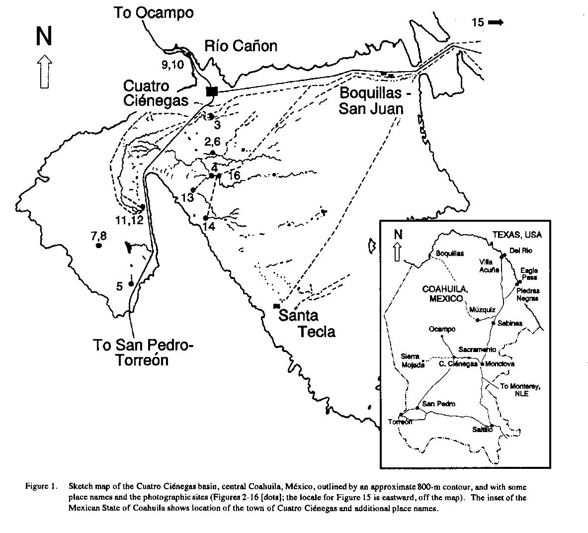
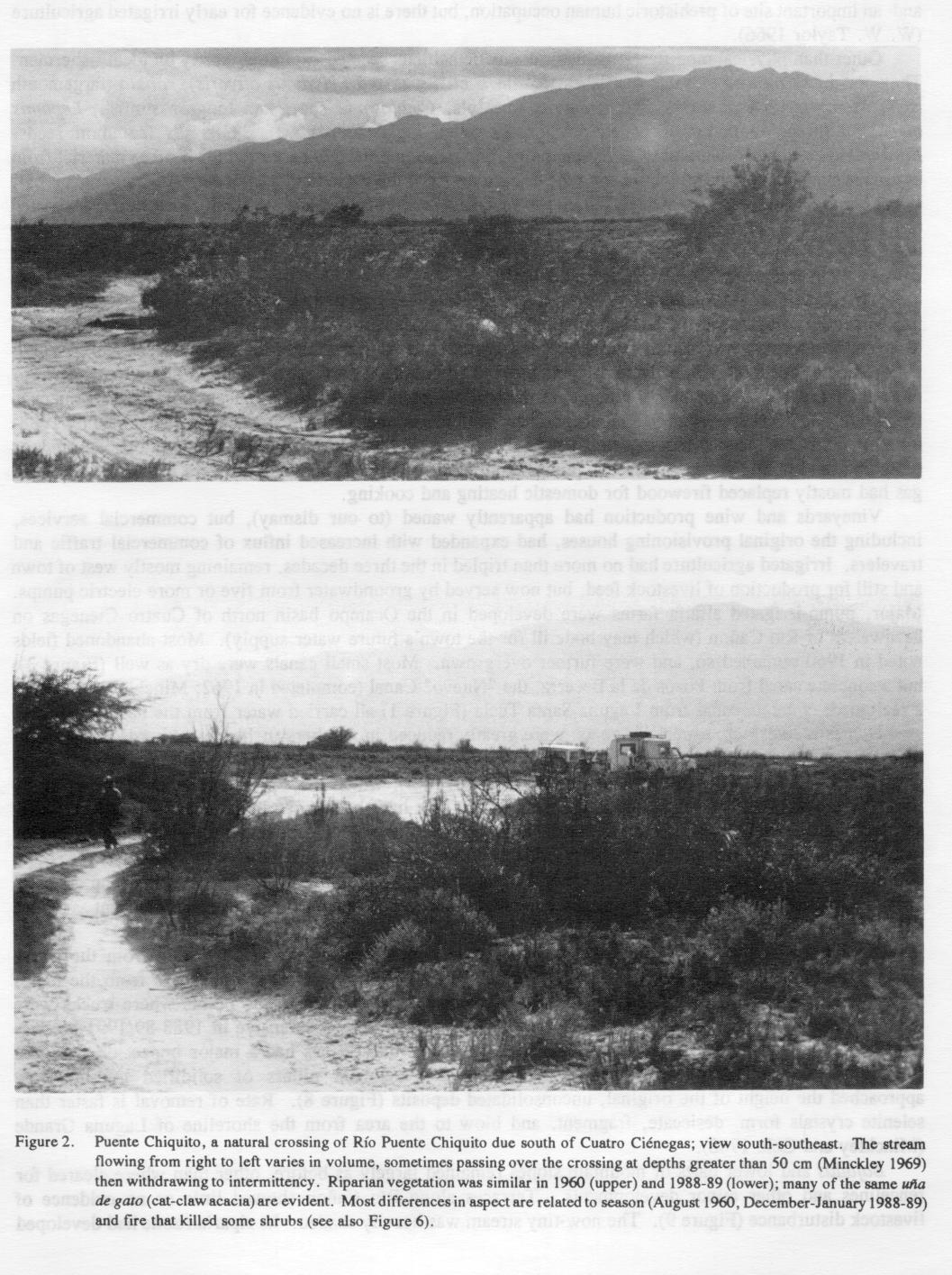
Original Data and Impressions. In 1960, a paved highway from the east ended in the village of Cuatro Ciénegas. Except for a railroad spur that headed from Monclova, passed westward through Cuatro Ciénegas, and ended at Sierra Mojada, all surface travel west and south was over unimproved roads (Figures 2 and 3 ), mostly simple wheel scars cut in the desert. One improved gravel road passed northward to Ocampo.
Pepe Lugo estimated about 2500 persons residing in the entire basin, most of whom were concentrated in the town of Cuatro Ciénegas. A few smaller settlements were around the valley's periphery (Figure 1). Most household cooking and heating were by firewood. There were neither telephones nor electricity, little indoor plumbing, and water was supplied by gravity flow from hand-dug cisterns along Río Cañon.
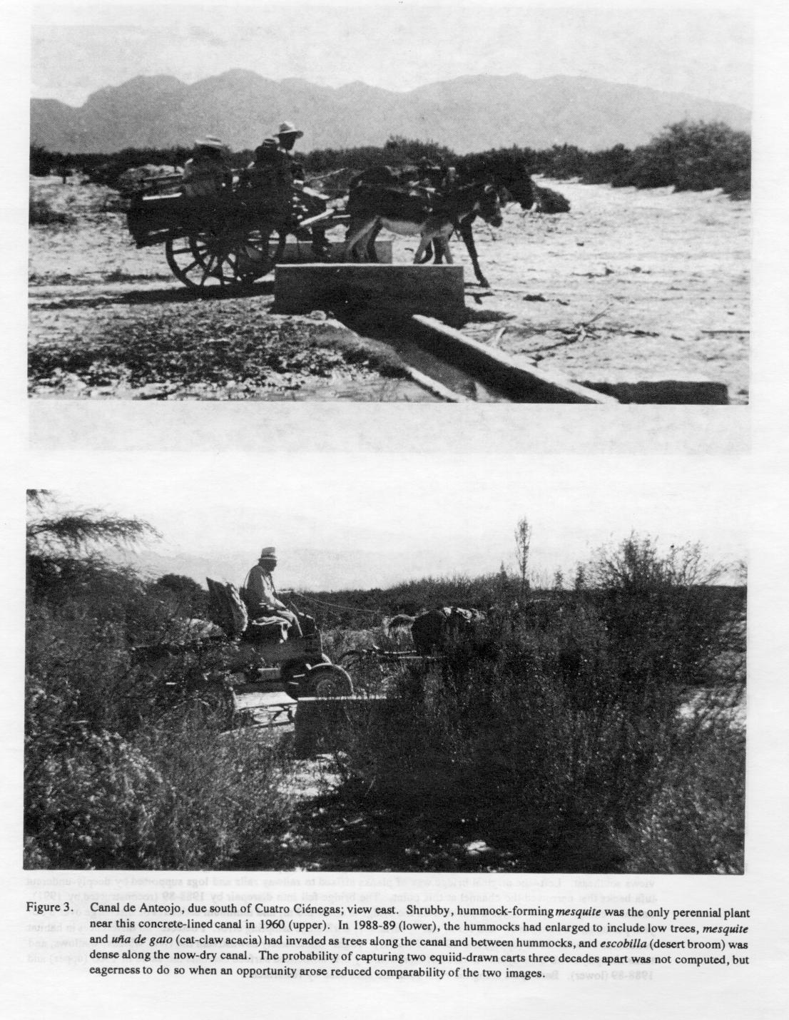
Wine production from local vineyards was the only evident industry, other than livestock ranching and import and warehouse facilities provisioning rural areas to the west and south. Cuatro Ciénegas lies at the eastern edge of the Bolsón de Mapimi, a vast, isolated, sparsely populated area of internal drainage used principally for ranching and mining. In addition to vineyards, evident human impacts near the village (mostly west) included scattered fields for producing livestock feed. Active agriculture was watered by gravity-flow canals tapping natural springs and watercourses. Only one diesel-powered groundwater pump was noted. Substantial fields south and east of town had been abandoned years before, based on extensive invasion by mesquite (Prosopis glandulosa), escobilla (desert broom, Baccharis sp.), and nopal (prickly pear, mostly Opuntia phaeacantha). Old and new fencelines were supported by wooden posts, mostly of mesquite.
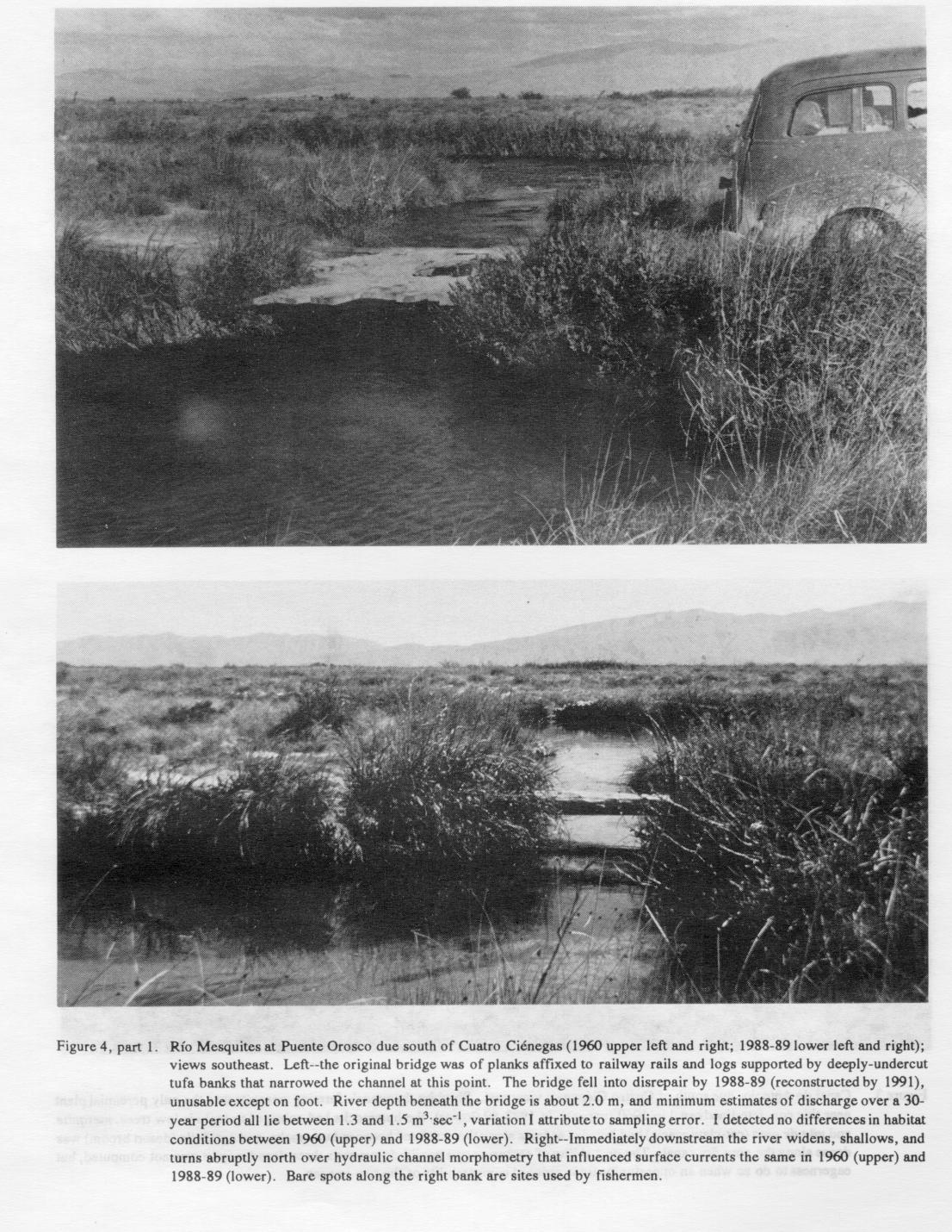
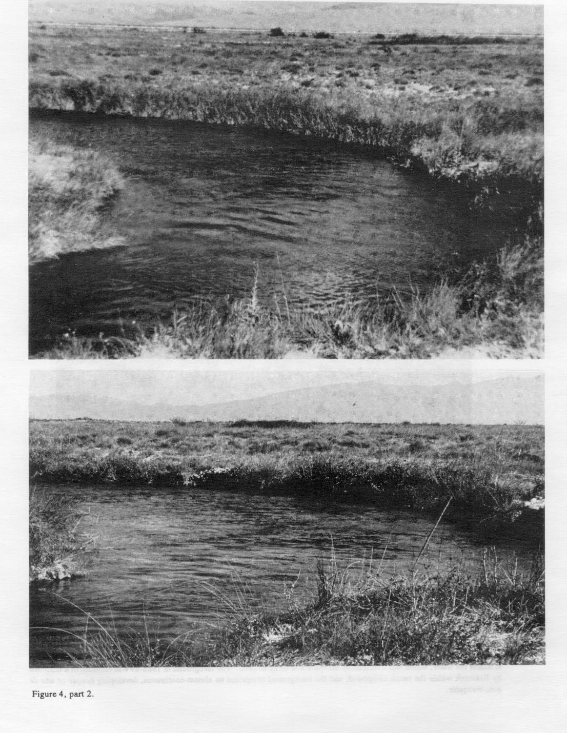
Some irrigation canals were hand-dug, only one was concrete-lined (Figure 3), and many were in disrepair. An earthen canal flowed north-northeast out of the basin from Laguna Santa Tecla (Figure 1 ). Another major, "Nuevo" Canal was under construction, breaching the broad alluvial sill that originally isolated central parts of the basin floor from external drainage. The canal was oriented east to west, and aligned to intercept Río Mesquites, a major stream that serves to consolidate the outflow of a number of large springs (Figure 4, part 1 and 2 ).
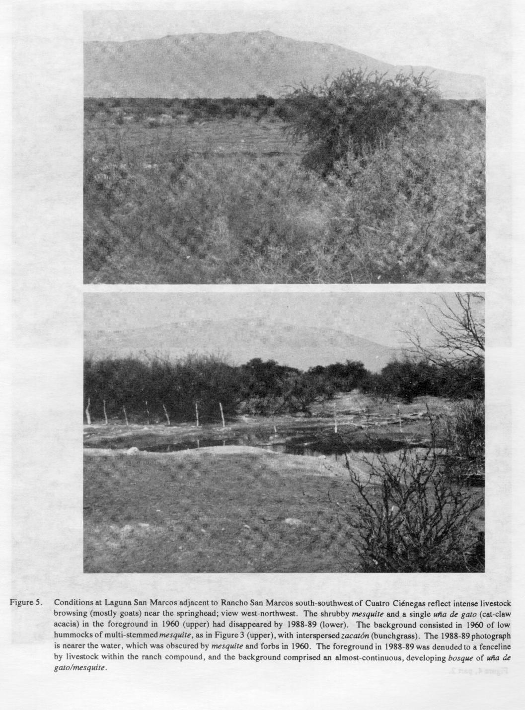
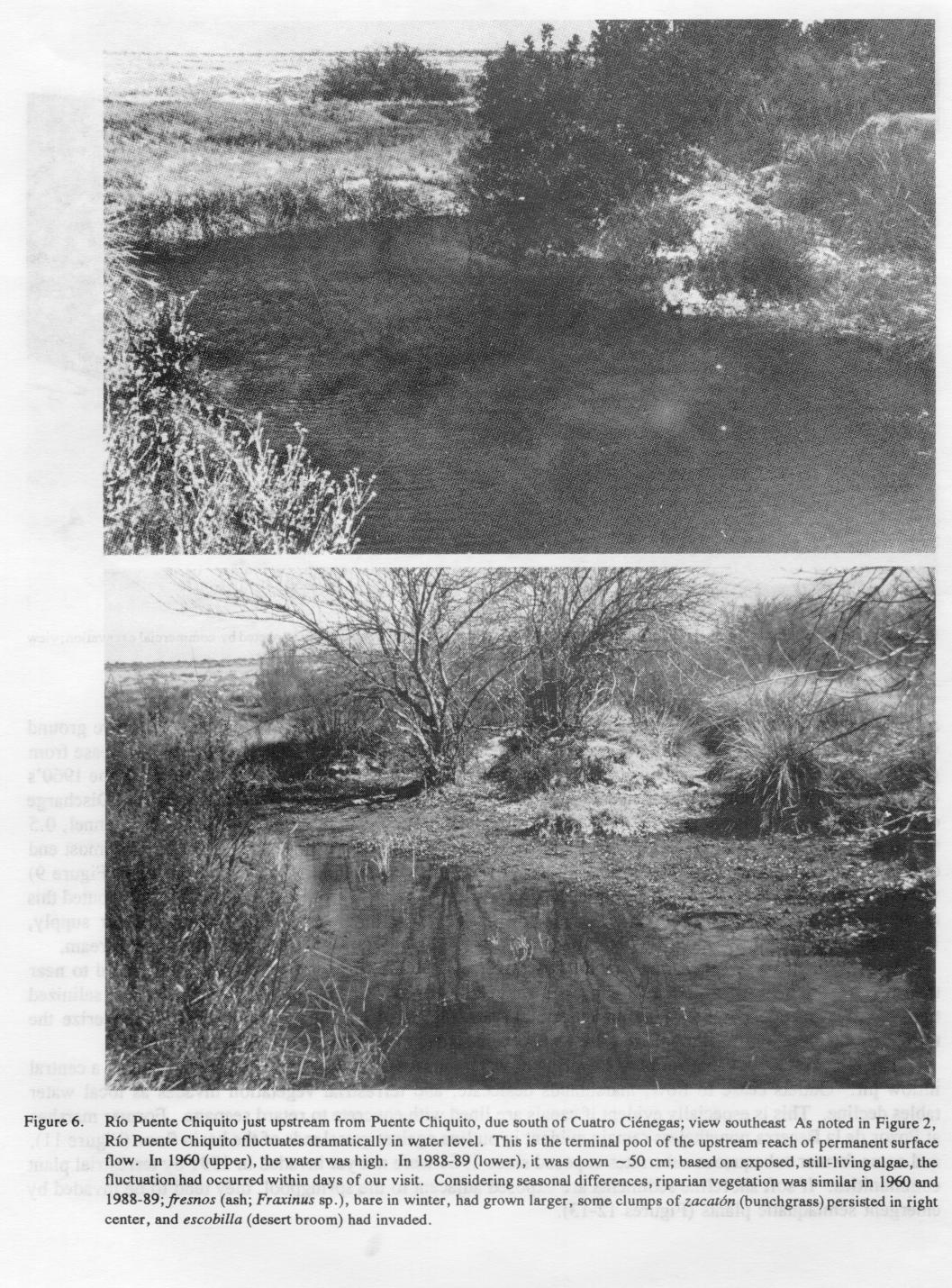
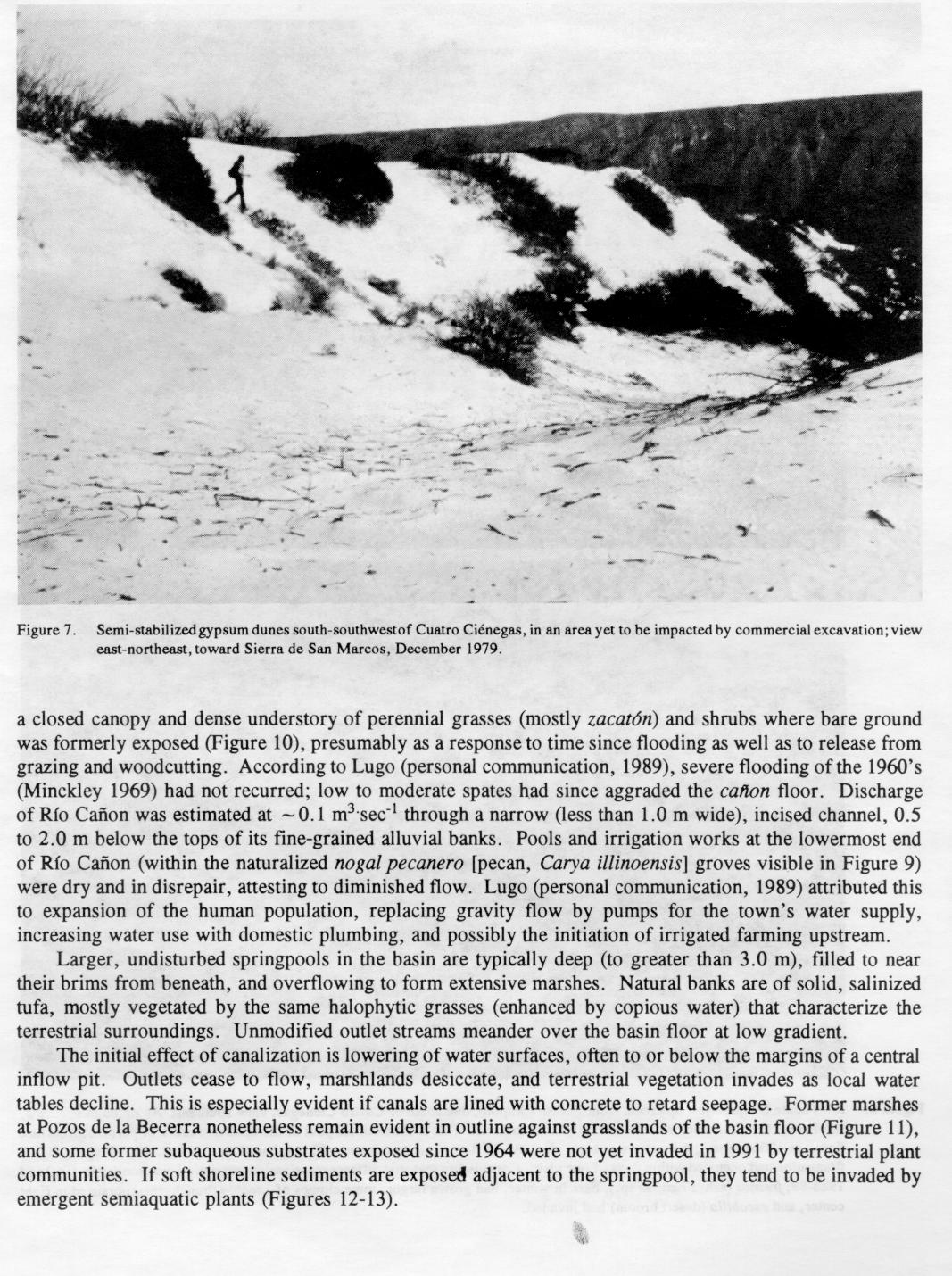
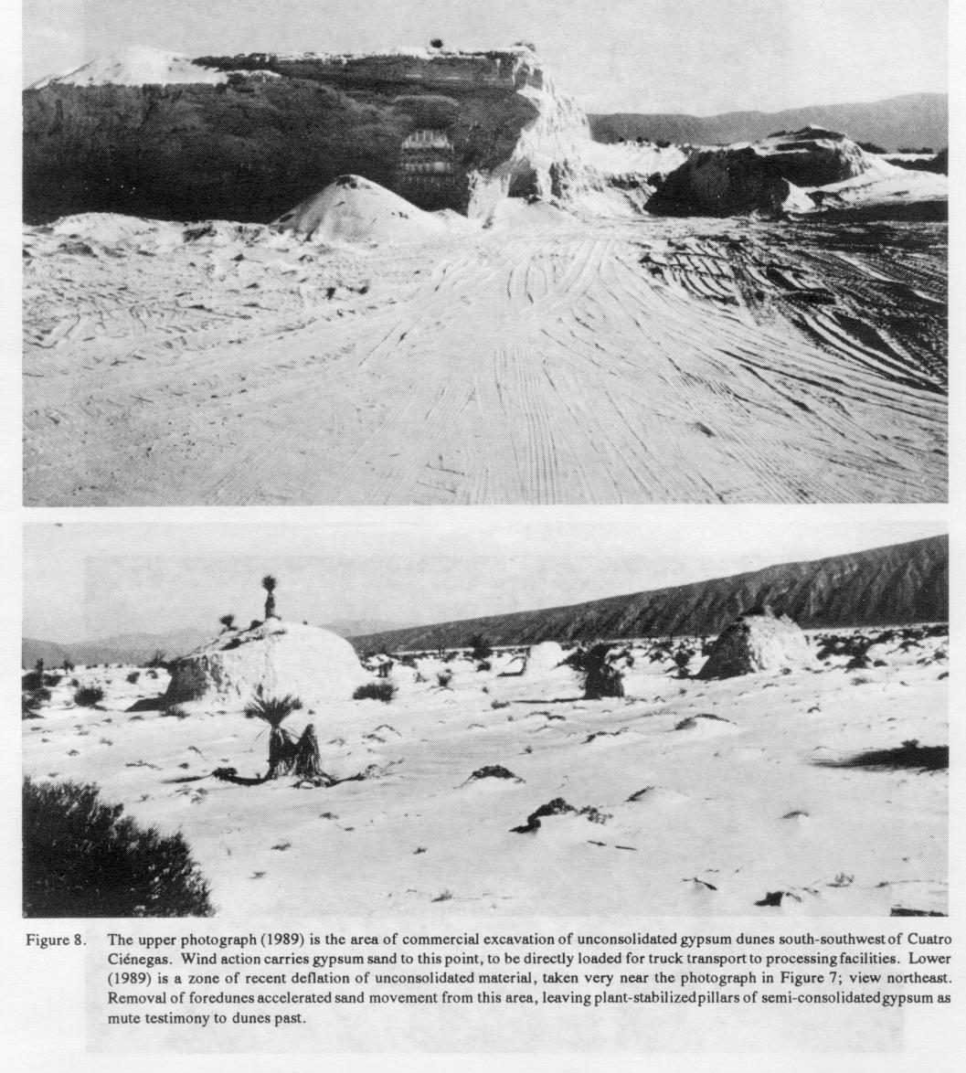
Domestic goats had almost denuded landscapes near settlements (Figures 3 and 5). Substantial herds of more than 50 animals were often encountered near towns, and also in remote areas on the basin floor. Small numbers of semi-wild horses were common; cattle and feral burros were few. Most of the basin floor was carpeted by an intact prairie, crossed by a few roads and old canals and diversified by scattered saline pools, streams, and stabilized gypsum dunes. Wildfires, either human- or lightning-caused, were common, and must have precluded (along with high water tables and pervasive soil salinity) shrub and tree invasions. Streams on the basin floor meandered between low banks, rarely vegetated by other than halophytic grasses or low shrubs (Figures 4, part 1 and 2 and 6). Active dunes of pure white gypsum in the southwestern lobe of the basin (not visited until 1964) rose to at least 10 m high (Figures 7 and 8), less extensive but reminiscent of those at White Sands, New México.
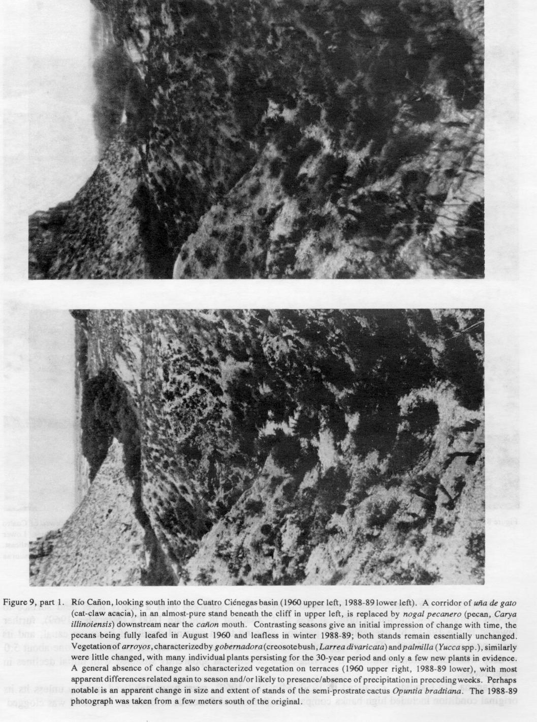
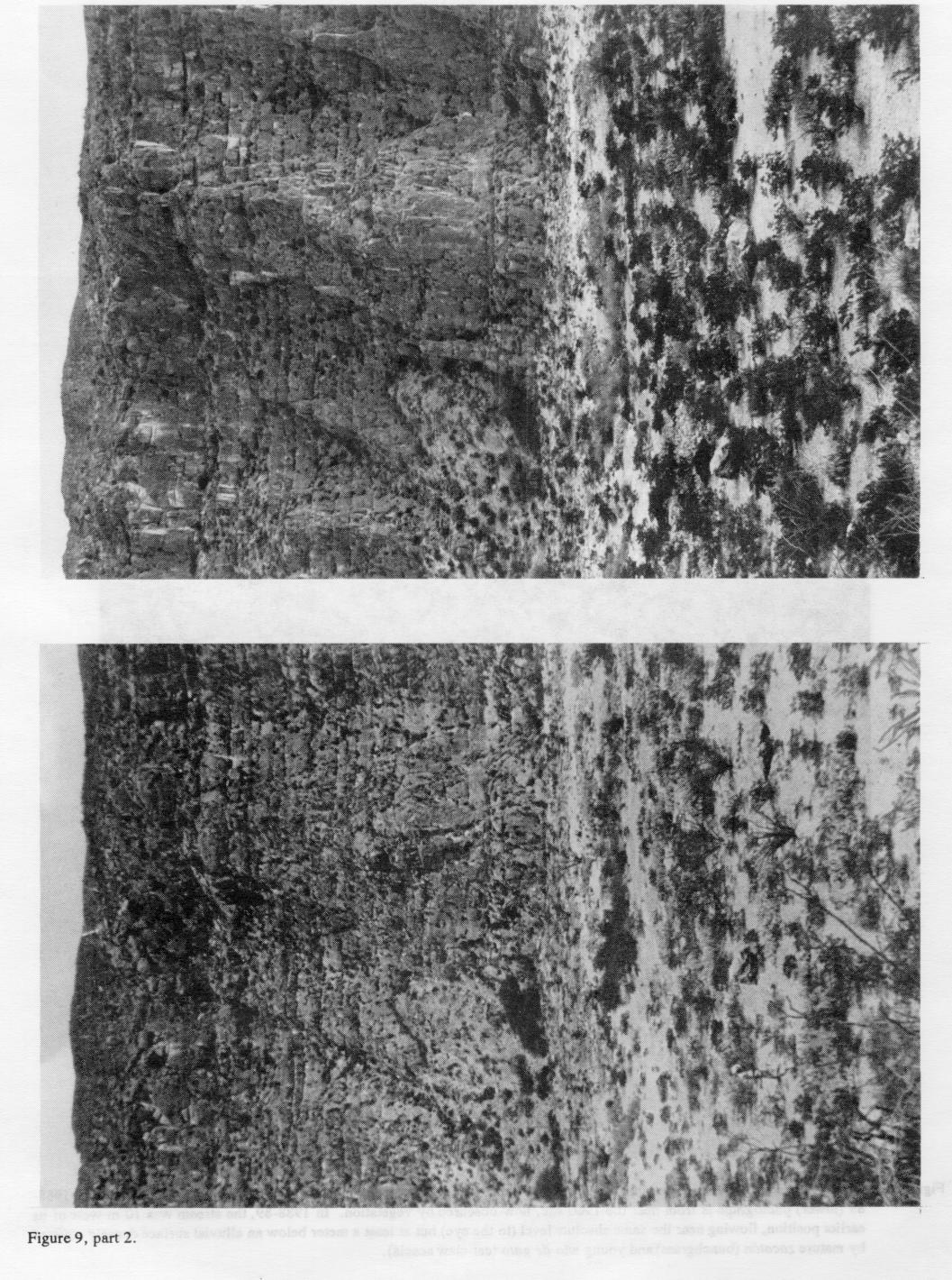
Lower slopes (bajadas) of the surrounding mountains seemed even less used by humans (Figure 9, part 1 and 2 ). Goat herds foraged along Río Cañon, but other livestock use seemed minimal. Harvest of native plants, candellila (Euphorbia antisyphalitica) for oil, lechequilla (Spanish bayonet, Agave lechequilla) for fiber, herbs, and fruits of various cacti for food, all were observed. Two major areas of mesquite bosques (forests), one each in the southeastern and southwestern lobes of the basin, and a riparian bosque mostly of uña de gato (cat-claw acacia, Acacia greggii; Figures 9 (part 1 and 2 ) and 10) along Río Cañon, all were heavily cut for posts and firewood.
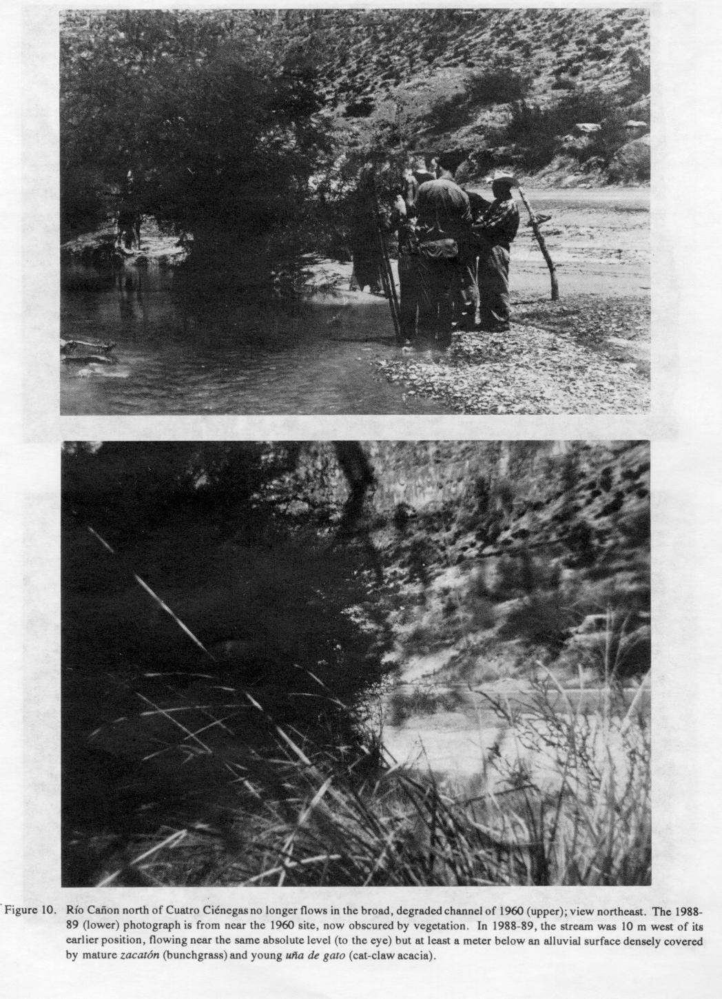
In the 1960's, Río Cañon had a base flow of - 0.25 M3 sec-1 through a broad, eroded channel (Figure 10). Riffles were 10 to 25 cm deep and a meter wide, and pools varied from 20 to 75 m long, to ~ 2.5 m wide, and a meter deep (Minckley 1969). Its riparian community lacked an understory; the Cañon floor had been scoured by flooding and severely trampled by livestock.
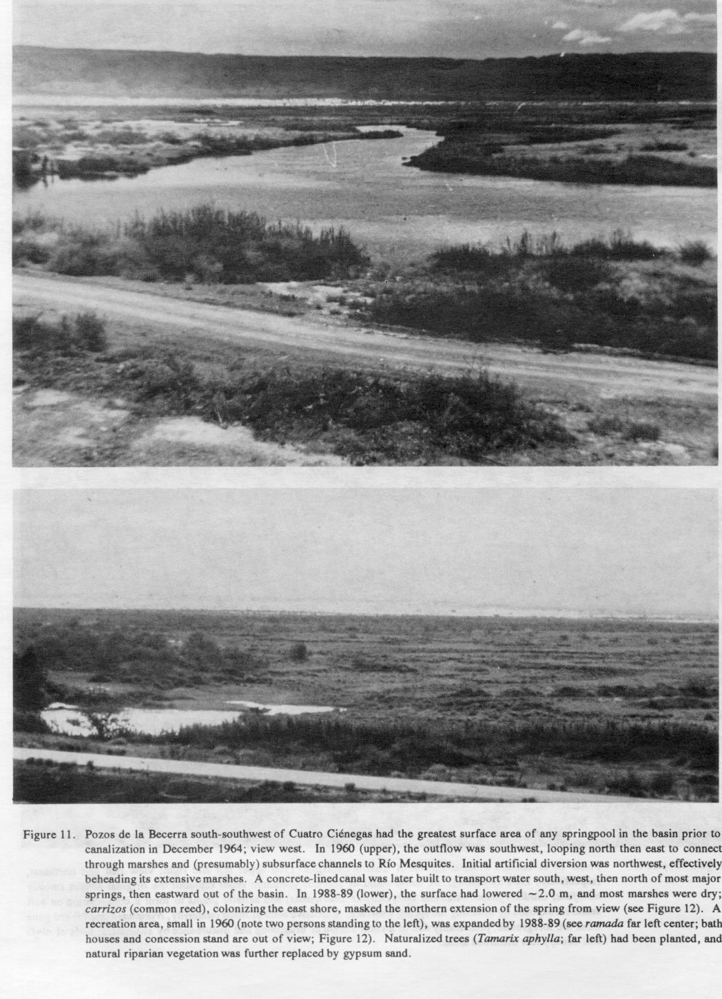
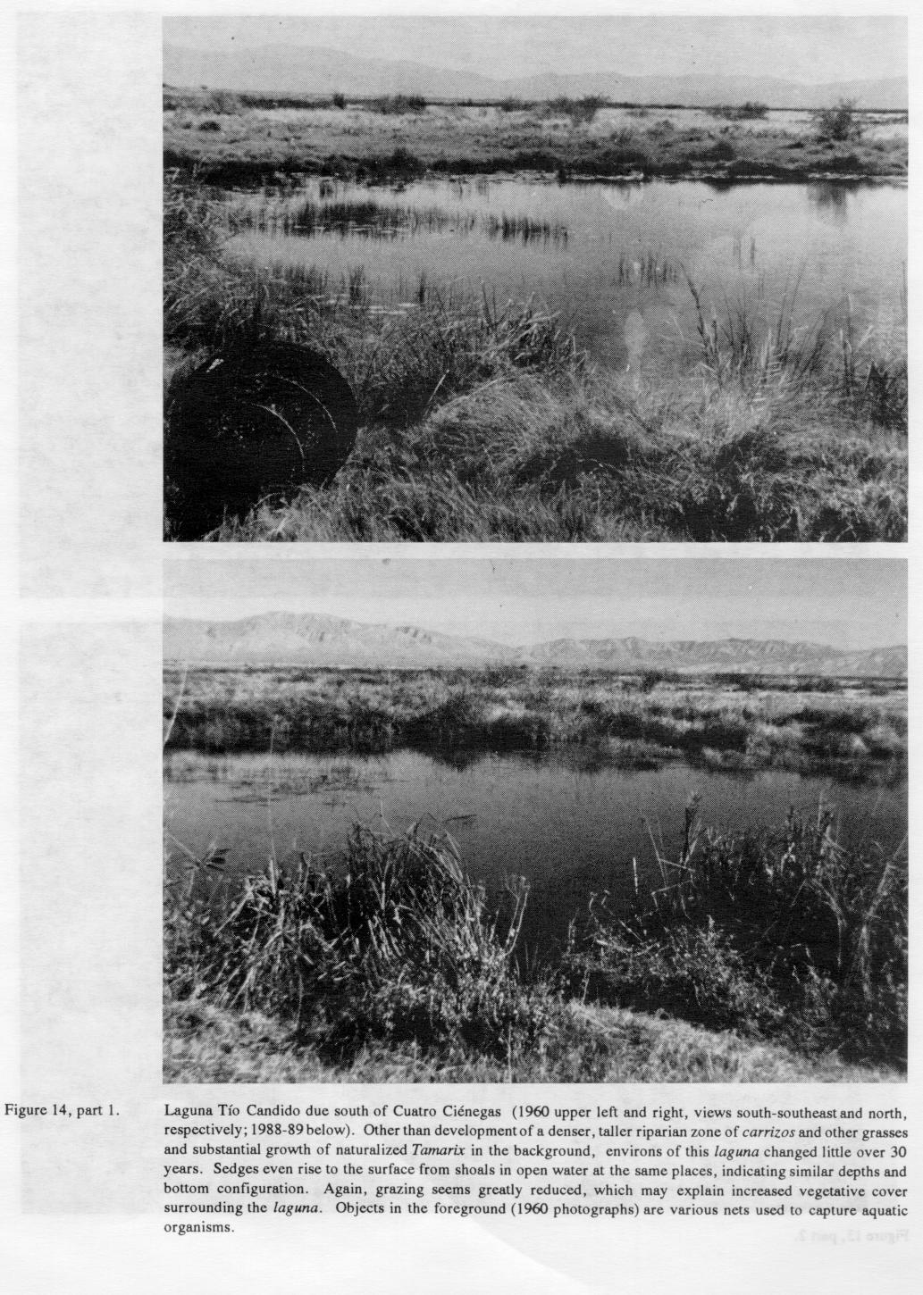
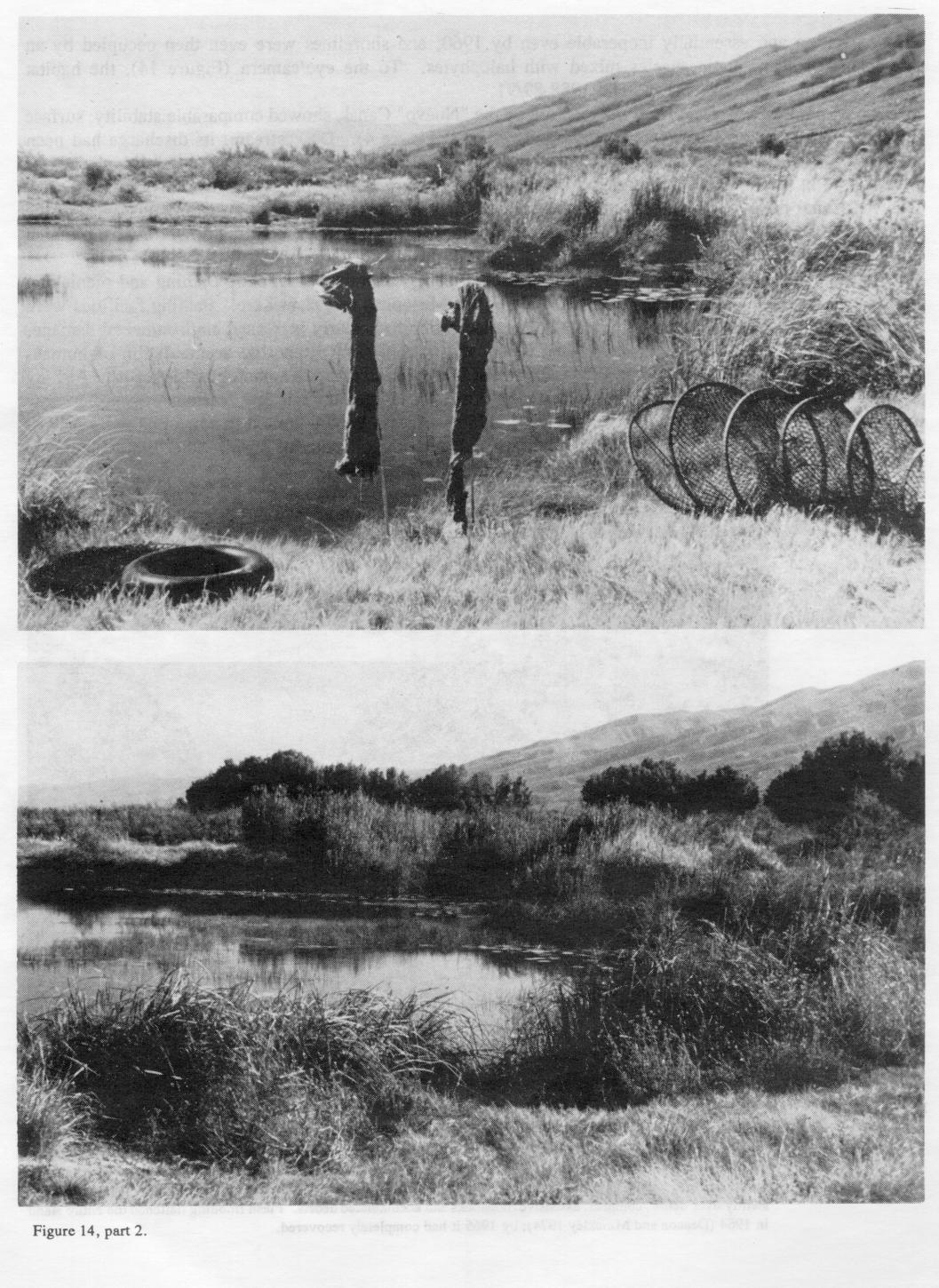
Many springpools (locally called pozos or lagunas; Figures 11 , Figure 12 (part 1 and 2 ), Figure 13 (part 1 and 2 ) and Figure 14, part 1 and 2 ) were already canalized when the basin was first visited by biologists. Routes of old canals are marked by faint linear depressions, and some of these may well date to the first occupation by Spaniards in the 16th century (Alessio-Robles 1938). Some canals still in use in 1960 had been built in the 1890's (Minckley 1969). The area is archaeologically rich and an important site of prehistoric human occupation, but there is no evidence for early irrigated agriculture (W. W. Taylor 1966).
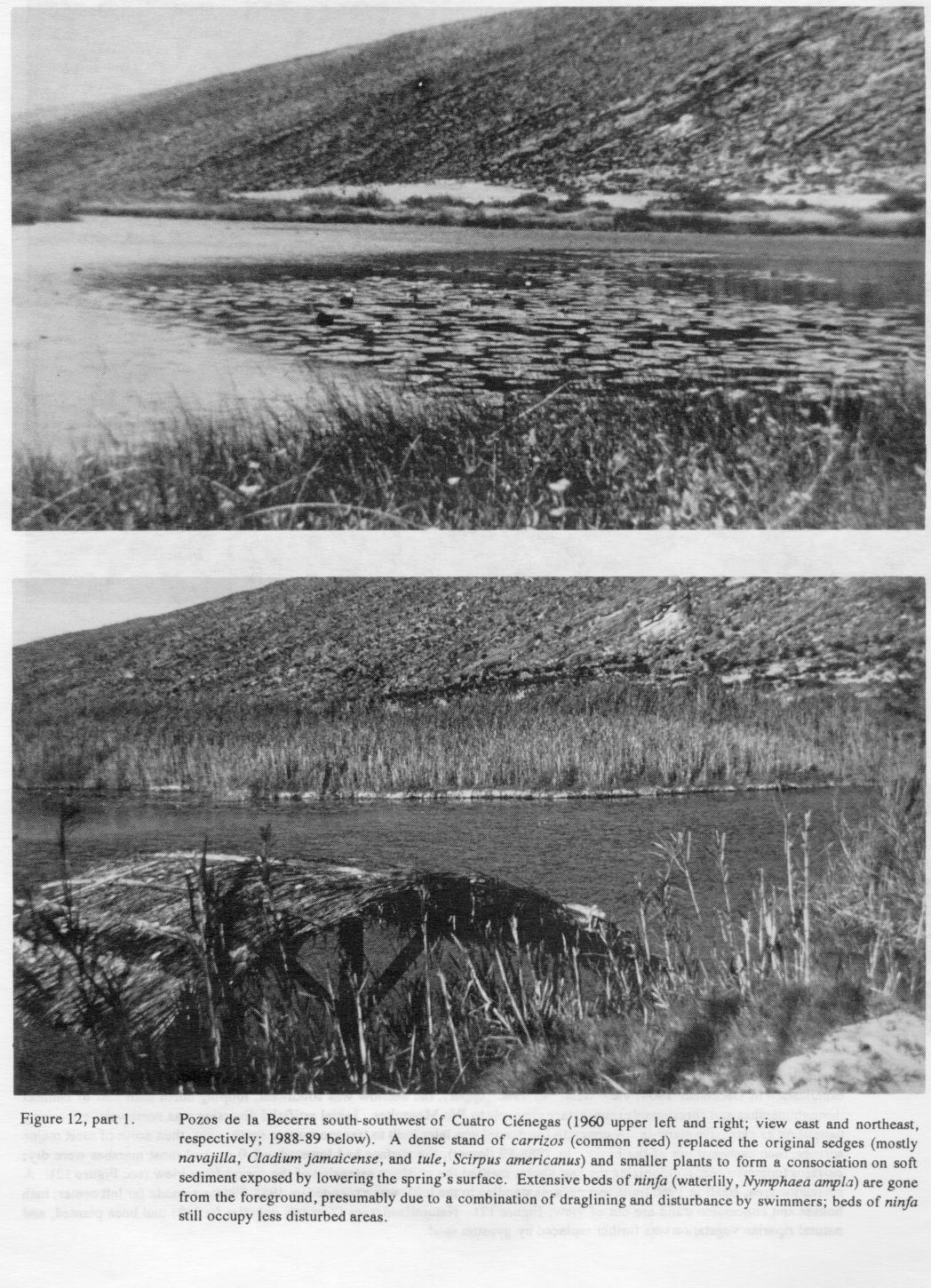
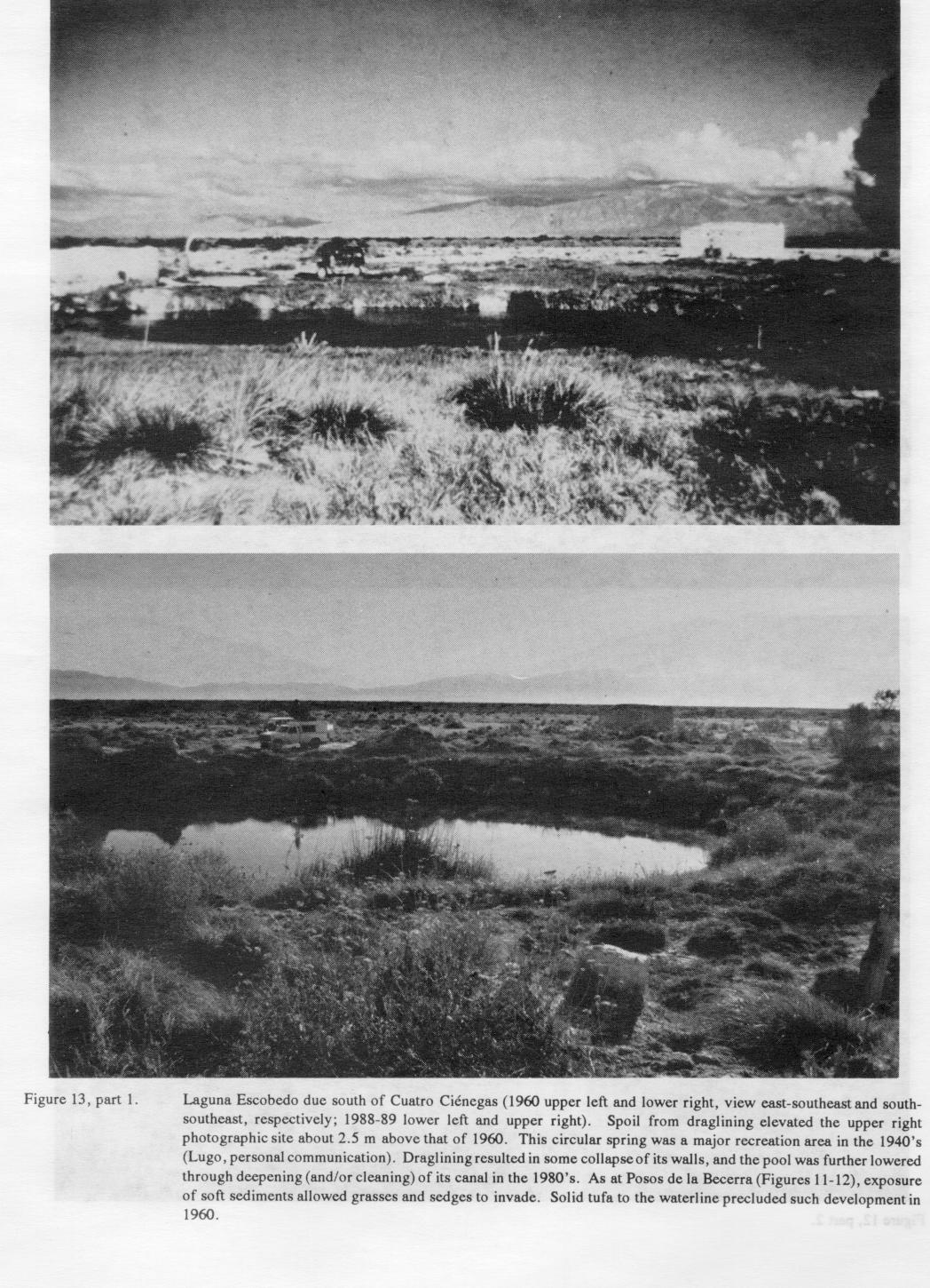
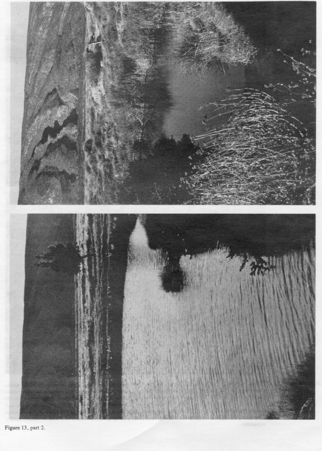
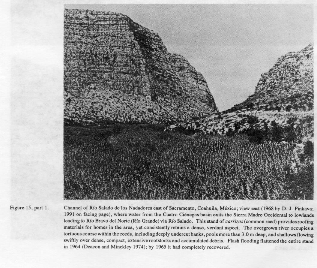
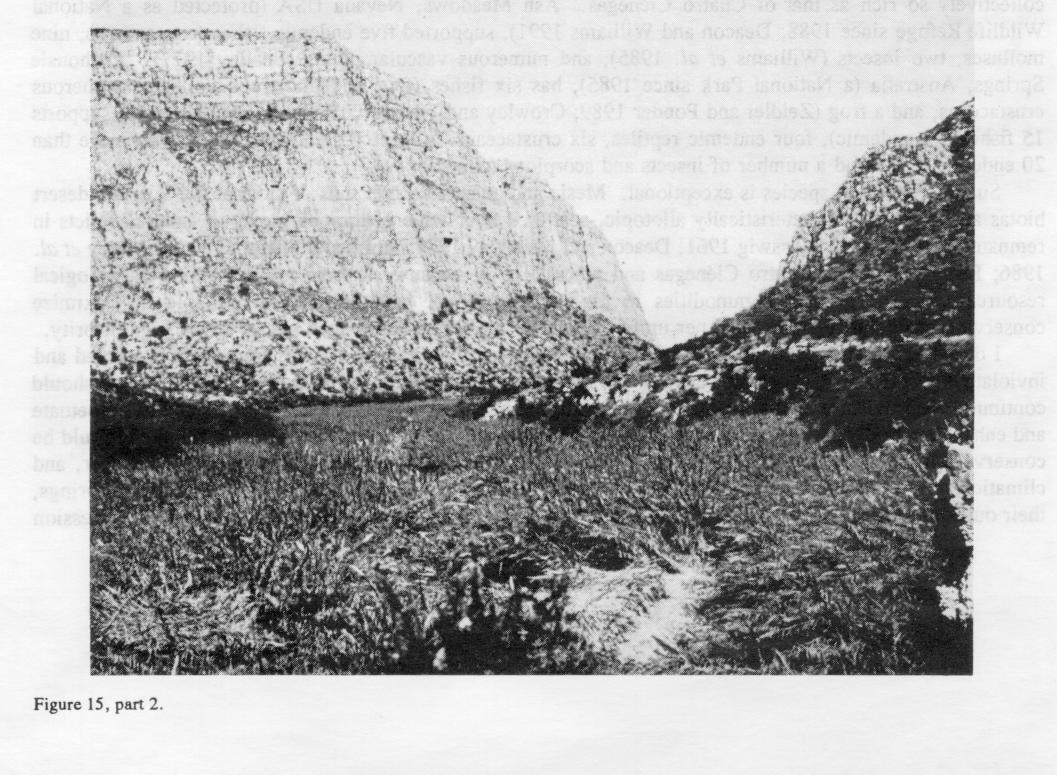
Other than physical modifications, natural aquatic habitats seemed exploited mostly by local fishermen. They sought bagre and pildonte (catfishes, Ictalurus cf. lupus and Pylodictis olivaris), robalo largemouth bass, Micropterus salmoides), and mojarras (cichlids, Cichlasoma spp., and longear sunfish, Lepomis megalotis [breeding males of which are locally called mojarras azules]). Carrizos (common reeds, Phragmites communes) were used as fishing poles, and more importantly harvested for roofing material from extensive stands along the stream leaving the eastern outlet of the basin (and east of Sacramento; Figure 15, part 1 and 2 ). Local families bathed and washed clothing in streams and springs near roads. A small recreation area existed at Pozos de la Becerra (Figure 11 and Figure 12, part 1 and 2 ), and another bathhouse and an old cantina with an encircling rock wall were abandoned at a bathing area at Laguna Escobedo Figure 13 (part 1 and 2 ), the warmest (~34.4'C), most constant-temperature spring yet found in the basin.
Change and lack of Change. -Three Decades Later. -By 1988-89 a paved, heavily-traveled 'highway passed south through Cuatro Ciénegas to connect with a major east-west route near San Pedro and Torreon. The road to Ocampo was also paved. Improved gravel roads followed the railroad westward and along all major canals, but most others remained unimproved (Figures 2 and 3). Cuatro Ciénegas alone had grown to more than 15,000 inhabitants. Communal farms (ejidos) established by the Méxican federal government in the 1960's and 1970's resulted in a number of new settlements, many of which had been abandoned by 1988-89/1991 with the people moving to Cuatro Ciénegas. Public electricity, telecommunications, indoor plumbing, and public water via electric pumps from alluvial fill of Río Cañon all were available. Propane gas had mostly replaced firewood for domestic heating and cooking.
Vineyards and wine production had apparently waned (to our dismay), but commercial services, including the original provisioning houses, had expanded with increased influx of commercial traffic and travelers. Irrigated agriculture had no more than tripled in the three decades, remaining mostly west of town and still for production of livestock feed, but now served by groundwater from five or more electric pumps. Major, pump-irrigated alfalfa farms were developed in the Ocampo basin north of Cuatro Ciénegas on headwaters of Río Cañon (which may bode ill for the town's future water supply). Most abandoned fields noted in 1960 remained so, and were further overgrown. Most small canals were dry as well (Figure 3), but a concrete canal from Pozos de la Becerra, the "Nuevo" Canal (completed in 1962; Minckley 1969), and a realigned, concrete canal from Laguna Santa Tecla (Figure 1) all carried water from the basin.
Domestic livestock, especially goats, were greatly reduced in numbers; neither goat herds nor signs of their presence were evident in remote areas. Mesquite, common in 1960, had become far more so near Cuatro Ciénegas and other settlements as well (Figures 3 and 5), which may be due to reduced browsing by livestock and the shift from firewood to propane. Cattle may have been more abundant, in fenced enclosures and fed alfalfa. None was seen on the basin floor, where numerous horses and a small number of burros still roamed on a saltgrass prairie swept by evidently frequent wildfires. There was little evidence for recent cutting of trees for posts or firewood in either bosque or along Río Cañon. New fences were strung on metal posts. Harvest of riparian carrizos was still evident, but the stands remained as dense and luxuriant as before (Figure 15, part 1 and 2 ).
A commercial processing plant for gypsum, surface-mined in an almost pure state from the active western dunefield (Figures 7 and 8), was opened in the 1970's. Initially, most removal was from the lee of dunes where tongues of granular gypsum sand were delivered by wind to the points where trucks were loaded. Excavation then extended into the dunefield, which remained extensive in 1988-89/1991 but was clearly becoming depleted of unconsolidated material. This harvest has had a major impact on that area (Contreras-Balderas 1984), and only mesquite-stabilized, remnant pillars of solidified gypsum now approached the height of the original, unconsolidated deposits (Figure 8). Rate of removal is faster than selenite crystals form, desiccate, fragment, and blow to the area from the shoreline of Laguna Grande (Minckley and Cole 1968).
Bajadas and lower parts of mountain slopes remained largely as before, other than where cleared for fencelines and -other minor developments. Terraces along Río Cañon showed little or no evidence of livestock disturbance (Figure 9, part 1 and 2 ). The now-tiny stream was heavily shaded. Its riparian zone had developed a closed canopy and dense understory of perennial grasses (mostly zacaton) and shrubs where bare ground was formerly exposed (Figure 10), presumably as a response to time since flooding as well as to release from grazing and woodcutting. According to Lugo (personal communication, 1989), severe flooding of the 1960's (Minckley 1969) had not recurred; low to moderate spates had since aggraded the Cañon floor. Discharge of Río Cañon was estimated at - 0. 1 m3 .sec-1 through a narrow (less than 1.0 m wide), incised channel, 0.5 to 2.0 m below the tops of its fine-grained alluvial banks. Pools and irrigation works at the lowermost end of R o Canon (within the naturalized nogal pecanero [pecan, Carya illinoensis] groves visible in Figure 9, part 1 and 2 ) were dry and in disrepair, attesting to diminished flow. Lugo (personal communication, 1989) attributed this to expansion of the human population, replacing gravity flow by pumps for the town's water supply, increasing water use with domestic plumbing, and possibly the initiation of irrigated farming upstream.
Larger, undisturbed springpools in the basin are typically deep (to greater than 3.0 m), filled to near their brims from beneath, and overflowing to form extensive marshes. Natural banks are of solid, salinized tufa, mostly vegetated by the same halophytic grasses (enhanced by copious water) that characterize the terrestrial surroundings. Unmodified outlet streams meander over the basin floor at low gradient. The initial effect of canalization is lowering of water surfaces, often to or below the margins of a central inflow pit. Outlets cease to flow, marshlands desiccate, and terrestrial vegetation invades as local water tables decline. This is especially evident if canals are lined with concrete to retard seepage. Former marshes at Pozos de la Becerra nonetheless remain evident in outline against grasslands of the basin floor (Figure 11), and some former subaqueous substrates exposed since 1964 were not yet invaded in 1991 by terrestrial plant communities. If soft shoreline sediments are exposed adjacent to the springpool, they tend to be invaded by emergent semiaquatic plants (Figure 12, part 1 and 2 and Figure 13, part 1 and 2 ).
Prior to canalization, Laguna Escobedo (Figure 13, part 1 and 2 ) discharged over a nearly level land surface to deposit a broad, low mound of tufa. It was first canalized in the late 1800's (Minckley 1969), further lowered in the 1980's by deepening (or perhaps cleaning to an original depth) of its outlet canal, and its springpool was draglined. The springpool nonetheless retains a natural aspect, an inverted cone about 5.0 m deep with soft bottom sediments overlying slabs of tufa that apparently slumped with initial declines in water levels.
Laguna Tio Candido, canalized in 1950 (Minckley 1969), must have stabilized quickly unless its its original condition included high banks compared with those of Pozos de la Becerra. Its canal was clogged with vegetation and essentially inoperable even by 1960, and shorelines were even then occupied by an assemblage of semiaquatic species mixed with halophytes. To the eye/camera (Figure 14, part 1 and 2 ), the habitat appeared unchanged between 1960 and 1988-89/91.
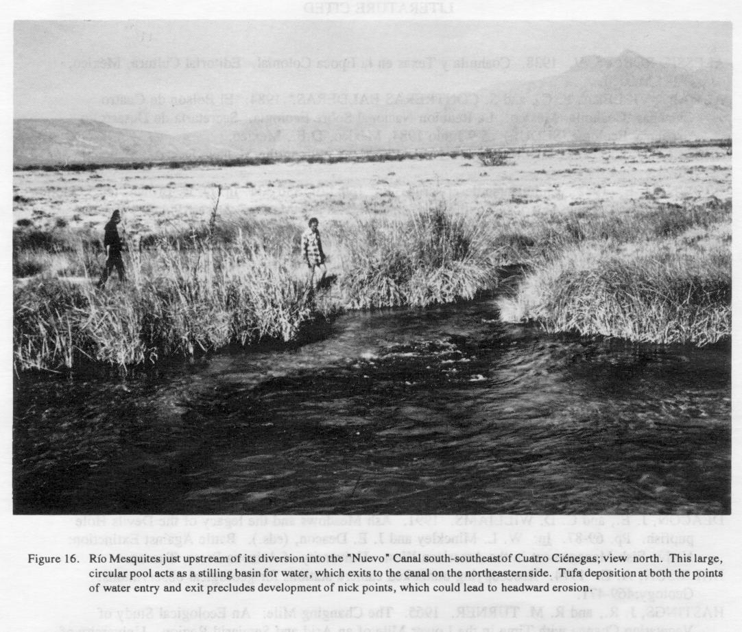
Río Mesquites, upstream from interception by the "Nuevo" Canal, showed comparable stability; surface currents even indicated a constancy in hydraulic control (Figure 4, part 1 and 2 ). Downstream, its discharge had been successfully diverted, leaving a dry channel winding eastward. There are no early photographs of the diversion point (Figure 16), but tufa deposition appeared to be protecting the system from headcutting. The "Nuevo" Canal flows away at a low gradient until passing over concrete control structures just west of the villages of Boquillas and San Juan (Figure 1), where gradient increases abruptly and downflow from which some of the canal is lined with concrete.
Recreational development increased after highway completion in the 1970's. Bathing and picnicking facilities and activity, and fishing, intensified along Río Mesquites and elsewhere. Bathing facilities were expanded at Pozos de la Becerra (Figure 11 and Figure 12, part 1 and 2 ). Recreation has clearly increased environmental damage, compacting and denuding stream and laguna banks and bottoms and promoting accumulation of human-generated debris (Contreras-Balderas 1984), for which I have yet to compile a photographic record. Fishing success has declined, ostensibly as a result of over-harvest and even though few "serious' fishermen now frequent the area (Lugo, personal communication, 1989). Access is now limited in some places by private and governmental closures, and fishing is prohibited (along with collection of certain other biotic elements) as part of governmental conservation efforts (Contreras-Balderas 1991).
SUMMARY AND DISCUSSION
Conclusions from the Photographic Record. -Comparisons of paired photographs in the Cuatro Ciénegas basin over a 30-year period indicate ecological change in habitats directly influenced by humans, but essentially none in those remote from human activities. Some technological advances, a transition from firewood to propane for cooking and heating, use of metal instead of wooden fenceposts, a shift from wideranging grazing of numerous livestock to reduced herds in fenced enclosures, had positive effects on local vegetation. On the negative side, electric pumps removing water from subsurface aquifers and deepening and concrete lining of canals lowered surface water levels and local water tables as well, surface mining of gypsum dramatically altered dunefield habitats, and increased human population is reflected in intensified recreation and accumulation of human-generated debris, degrading both terrestrial and aquatic habitats.
Some aquatic habitats have been sorely disrupted by direct development. Those suffering most have been canalized, which lowers water levels and dramatically reduces surface areas, or developed for recreation that severely disturbs shorelines and bottoms through direct human activity, or both. Marshlands associated with canalized springs are substantially reduced in area. Only a few springs have been destroyed through desiccation (Minckley 1969), but a number of formerly permanent and extensive marshes are now dry or only seasonally wet. Earthen canals passing over the basin floor may result in lowering of water tables, but this has not yet resulted in other than local impacts. Canals do, however, connect localities and habitats, allowing formerly isolated biotic elements to intermingle and in some cases hybridize (Minckley 1978) and increasing potential for invasion of exotic organisms. Electric pumps removing water from subsurface aquifers and deepening and concrete lining of canals lowered surface water levels and local water tables as well. Pumps are not yet in use other than in the immediate vicinity of Cuatro Ciénegas and northward in the Ocampo Valley.
Despite these negative changes, much of the Cuatro Ciénegas basin remains intact. Two major reasons for persistence of the ecosystem in the face of actual and potential development seem clear. First, terrestrial habitats have little potential for direct human use. Those on the basin floor suffer edaphic conditions (mostly soil salinity) that preclude extensive agriculture, aridity and sparseness of vegetation on bajadas make them inhospitable, while the rugged surrounding mountains remain difficult of access and remote. Second, high total dissolved solids in most of the basin's waters, including substantial amounts of magnesium sulfate and sodium chloride (Minckley and Cole 1968), minimizes their usefulness. Thus, pumping from the aquifer(s), which has immediate and catastrophic impacts on such systems, has not yet been applied to any substantial degree. High-quality (low total dissolved solids) water supplies seem limited and scarcely sufficient for other than domestic uses.
A Plea for Area Conservation. -By all measures, the scientific values of the Cuatro Ciénegas basin are profound, far exceeding the monetary value of its land and water supply as resources for typical development. Only a few such places, rich in species and with habitat diversity of regional extent in a small area, exist in any other and zone. The valley itself includes only about 1200 km2, within which is packaged a remarkably large percentage of the biota of the vast Chihuahuan Desert Region. For example, at least 64 native amphibians and reptiles have been recorded from below 1000 m elevation in the basin (McCoy 1984), comprising more than a third of the 170 species Morofka (1977) identified in his analysis of the entire Chihuahuan Desert herpetofauna! If one includes the surrounding mountains, only doubling or at most tripling the area of coverage from that of the basin floor, vegetative communities vary from desert scrub to woodlands, to chaparral, and to dense coniferous forest, all in a minuscule geographic area. Other biotic elements are equally diverse (see, e.g., Wauer and Riskind 1978). Superimposed on this array is the rich and varied relict and endemic biota, consisting of an unusually dense concentration of mesic and aquatic species.
Similar-sized pockets of aquatic diversity are known in other desert lands, but none known to me is collectively so rich as that of Cuatro Ciénegas. Ash Meadows, Nevada USA (protected as a National Wildlife Refuge since 1988; Deacon and Williams 1991), supported five endemic fishes (one extinct), nine molluscs, two insects (Williams et al. 1985), and numerous vascular plants (Beatley 1977). Dalhousie Springs, Australia (a National Park since 1985), has six fishes (four endemic), six molluscs, numerous crustaceans, and a frog (Zeidler and Ponder 1989; Crowley and Ivantsoff 1990). Cuatro Ciénegas supports 15 fishes (12 endemic), four endemic reptiles, six crustaceans, at least 10 molluscs, along with more than 20 endemic plants and a number of insects and scorpions (cited above).
Such clumping of species is exceptional. Mesic and aquatic components of most of the World's desert biotas are far more characteristically allotopic, scattered over wide geographic areas as isolated relicts in remnant habitat islands (Kosswig 1961; Deacon and Minckley 1974; Smith and Miller 1986; Minckley et al. 1986; Leveque 1990). Cuatro Ciénegas and places like it, because of their concentrations of biological resources, are inexpensive commodities in the marketplace of land and water available to maximize conserving biodiversity. The yield per unit of effort (or dollars) is high; such places are of high priority.
I do not advocate setting aside the Cuatro Ciénegas basin as a static system, rigorously preserved and inviolate in its present state or reconstructed toward some past condition. Human use of surface water should continue, but provisions should be made to maintain the integrity of now-isolated habitats and to perpetuate and enhance not only specific sites but also the broader habitat types within the system. The area should be conserved, for example, so that springs and marshes may wax and wane naturally with season, year, and climatic cycle, rather than being raised and lowered by changes in canal outlets. Dynamics of the springs, their outflows, marshes, and sumps should be conserved as intact ecosystems, where continuing succession and evolution of both the habitat and biota can be assured. Access roads must be permanently established rather than allowing random travel over the desert floor, recreation areas should be concentrated and carefully managed, and so on. This special place should be set aside for use as a natural laboratory for research and education, placed under careful stewardship in perpetuity for the study of processes and mechanisms. As such it will be a refuge not only for unique habitats and biotas, but also for human minds so cluttered with the ravages of technology that exposure to natural places and processes will be a necessity for life.
Thirty years of photographic record may have little to do with these arguments for conservation, except to conclusively demonstrate that the Cuatro Ciénegas system changes slowly if at all in such a period of time unless influenced by human activities. The record further documents persistence of most of the unique habitats within this basin, despite human actions. Despite some negative impacts, indications are that most of its indigenous flora and fauna remains intact. From these perspectives, the area remains highly viable as a candidate for inclusion in a system of natural reserves. The Mexican government has already moved to protect parts of the basin and its biota (Almada-Villela and Contreras-Balderas 1984, Contreras-Balderas 1991). I commend this action and urge such efforts be intensified, expanded in scope, and vigorously continued. Perhaps this contribution may add fuel to that fire.
LITERATURE CITED
ALESSIO-ROBLES, V. 1938. Coahuila y Texas en la Epoca Colonial. Editorial Cultura, México, D.F., México.
ALMADA-VILLELA, P. C., and S. CONTRERAS-BALDERAS. 1984. El Bolson de Cuatro Ciénegas, Coahuila, México. La Reunion Nacional Sobre Ecologia. Secretaria de Desarrollo Urbano y Ecologia (SEDUE). 5-9 Junio 1984, México, D.F., México.
BEATLEY, J. C. 1977. Ash Meadows: Nevada's unique oasis in the Mohave Desert. Mentzelia 3: 20-24.
BROWN, D. E. 1982. Chihuahuan desert scrub. Pp. 169-179, 330-331. In: D. E. Brown, (ed.). Biotic Communities of the American Southwest - United States and México. Desert Plants 4 (Special Issue).
COLE, G. A. 1984. Crustacea from the Bolson of Cuatro Ciénegas, Coahuila, México. Pp. 3-12. In: P. C. Marsh, (ed.). Biota of Cuatro Ciénegas, Coahuila, México: Proceedings of a Special Symposium, Desert Fishes Council (1983). Journal of the Arizona-Nevada Academy of Science 19.
CONTRERAS-BALDERAS, S. 1984. Environmental impacts in Cuatro Ciénegas, Coahuila, México: A commentary. Pp. 85-88. In: P. C. Marsh, (ed.), Biota of Cuatro Ciénegas, Coahuila, México: Proceedings of a Special Symposium, Desert Fishes Council (1983). Journal of the Arizona-Nevada Academy of Science 19. . 1991. Conservation of Mexican freshwater fishes: Some protected sites and species, and federal legislation. Pp. 191-197. In: W. L. Minckley and J. E. Deacon, (eds.). Battle Against Extinction: Native Fish Management in the American West. University of Arizona Press, Tucson.
CROWLEY, L. E. L. M., and W. IVANTSOFF. 1990. A second hardyhead, Craterocephalus gloveri (Pisces: Atherinidae), from Dalhousie Springs, central Australia. Ichthyological Exploration of Freshwaters 1: 1 13-122.
DEACON, J. E., and W. L. MINCKLEY. 1974. Desert fishes. Pp. 385-488. In: G. W. Brown, Jr., (ed.). Desert Biology, Vol. 2. Academic Press, Inc., New York.
DEACON, J. E., and C. D. WILLIAMS. 1991. Ash Meadows and the legacy of the Devils Hole pupfish. Pp. 69-87. In: W. L. Minckley and J. E. Deacon, (eds.). Battle Against Extinction: Native Fish Management in the American West. University of Arizona Press, Tucson.
HARRISON, A. E. 1974. Reoccupying unmarked camera stations for geological observations. Geology:469-471.
HASTINGS, J. R., and R. M. TURNER. 1965. The Changing Mile: An Ecological Study of Vegetation Change with Time in the Lower Mile of an Arid and Semiarid Region. University of Arizona Press, Tucson.
HERSHLER, R. 1984. The hydrobiid snails (Gastropoda: Rissoacea) of the Cuatro Ciénegas basin: Systematic relationships and ecology of a unique fauna. Pp. 61-76. In: P. C. Marsh, (ed.). Biota of Cuatro Ciénegas, Coahuila, México: Proceedings of a Special Symposium, Desert Fishes Council. Journal of the Arizona-Nevada Academy of Sciences 19.
HERSHLER, R 1985. Systematic revision of the Hydrobiidae (Gastropoda: Rissoacea) of the Cuatro Ciénegas basin, Coahuila, México. Malacologia 26:31-123.
HUBBS, C. L., and R. R. MILLER. 1965. Studies of cyprinodont fishes, XXII. Variation in Lucania parva, its establishment in western United States, and description of a new species from an interior basin in Coahuila, México. Miscellaneous Publications of the Museum of Zoology, University of Michigan 127:1-111.
KLETT, M., E. MANCHESTER, J. VERBERG, G. BUSHAW, R. DINGUS, and P. BERGER. 1984. Second View: The Rephotographic Survey Project. University of New México Press, Albuquerque. KOSSWIG, K. 1961. Speciation in the earlier Central Anatolian Lake basin. Pp. 561-593. In: W. F. Blair, (ed.). Vertebrate Speciation. University of Texas Press, Austin.
LEVEQUE, C. 1990. Relict tropical fish fauna in central Sahara. Ichthyological Exploration of Freshwaters 1:39-48.
MALDE, H. E. 1973. Geologic bench marks by terrestrial photography. United States Geological Survey Journal of Research 1: 193.
MCCOY, C. J., Jr. 1984. Ecological and zoogeographic relationships of amphibians and reptiles of the Cuatro Ciénegas basin. Pp. 49-60. In: P. C. Marsh, (ed.). Biota of Cuatro Ciénegas, Coahuila, México: Proceedings of a Special Symposium, Desert Fishes Council. Journal of the Arizona-Nevada Academy of Science 19.
MEYER, E. R. 1973. Late-Quaternary paleoecology of the Cuatro Ciénegas basin, Coahuila, México. Ecology 54:982-995.
MEYER, E. R. 1975. Vegetation and pollen rain in the Cuatro Ciénegas basin, Coahuila, México. The Southwestern Naturalist 30:215-224.
MINCKLEY, W. L. 1969. Environments of the Bolson of Cuatro Ciénegas, Coahuila, México, with special reference to the aquatic biota. Texas Western Press, University of Texas, El Paso'. Science Series 2:1-65.
MINCKLEY, W. L. 1978. Endemic fishes of the Cuatro Ciénegas basin, Coahuila, México. Pp. 383@. In: R. H. Wauer and D. Riskind, (eds.). Transactions of the Symposium on the Biological Resources of the Chihuahuan Desert Region, United States and México. United States National Park Service, Trans. Proc. Ser. 3.
MINCKLEY, W. L. 1984. Cuatro Ciénegas fishes: Research review and a local test of diversity versus habitat size. Pp. 13-22. In: P. C. Marsh, (ed.). Biota of Cuatro Ciénegas, Coahuila, México: Proceedings of a Special Symposium, Desert Fishes Council. Journal of the Arizona-Nevada Academy of Science 19.
MINCKLEY, W. L. and G. A. COLE. 1968. Preliminary limnologic information on waters of the Cuatro Ciénegas basin, Coahuila, México. The Southwestern Naturalist 13:421-431.
MINCKLEY, W. L., D. A. HENDRICKSON, and C. E. BOND. 1986. Geography of western North American freshwater fishes: Description and relationships to intracontinental tectonism. Pp. 519-613. In: C. H. Hocutt and E. 0. Wiley, (eds.). Zoogeography of North American Freshwater Fishes. John Wiley and Sons, New York.
MORAFKA, D. J. 1977. A biogeographical analysis of the Chihuahuan Desert through its herpetofauna. W. Junk, The Hague.
PINKAVA, D. J. 1979. Vegetation and flora of the Bolson of Cuatro Ciénegas region, Coahuila, México:1. Boletin de la Sociedad Botanica de México 38: 35-73.
PINKAVA, D. J. 1980. Ibid.: 11. Ibid. 39: 107-127.
PINKAVA, D. J. 1981. Ibid.: Ill. Ibid. 41: 127-151.
PINKAVA, D. J. 1984. Ibid.: IV. Summary, endemism and corrected catalogue. Pp. 23-47. In: P. C. Marsh, (ed.). Biota of Cuatro Ciénegas, Coahuila, México: Proceedings of a Special Symposium, Desert Fishes Council. Journal of the Arizona-Nevada Academy of Science 19.
SMITH, M. L., and R. R. MILLER. 1986. The evolution of the Río Grande basin as inferred from its fish fauna. Pp. 457-486. I-n: C. H. Hocutt and E. 0. Wiley, (ed.). Zoogeography of North American Freshwater Fishes. John Wiley and Sons, New York.
TAYLOR, D. W. 1966. A remarkable snail fauna from Coahuila, México. Veliger 9:152-228.
TAYLOR, W. W. 1966. Archaic cultures adjacent to the northeastern frontiers of Mesoamerica. Pp. 59-94. In: Handbook of Middle American Indians, Vol. 4. Archaeological Frontiers and External Connections. University of Texas Press, Austin.
TURNER, R. M. 1974. Quantitative and historical evidence for vegetation changes along the upper Gila River, Arizona. United States Geological Survey Professional Papers 655-H: 1-20.
TURNER, R. M. and M. M. KARPISCAK. 1980. Recent vegetation changes along the Colorado River between Glen Canyon Dam and Lake Mead, Arizona. Ibid. 1132:1-225.
WAUER, R. H., and D. RISKIND, (eds.). 1978. Transactions of the Symposium on the Biological Resources of the Chihuahuan Desert Region, United States and México. United States National Park Service, Trans. Proc. Ser. 3.
WILLIAMS, J. E, D. B., BOWMAN, J. E. BROOKS, A. A. ECHELLE, R. V. EDWARDS, D. A. HENDRICKSON, and J. J. LANDYE. 1985. Endangered aquatic ecosystems in North American deserts, with a list of vanishing fishes of the region. Journal of the Arizona-Nevada Academy of Science 20:1-62.
WILLIAMS, S. C. 1968. Scorpions from northern México: Five species of Vejovis from Coahuila, México. Occupational Papers of the California Academy of Science 68:1-24.
ZEIDLER, W., and W. F. PONDER, (eds.). 1989. Natural History of Dalhousie Springs. South Australian Museum, Adelaide.
Return to / Regrese a Cuatro Ciénegas Home Page DFC Home TNHC FISH Home. Page maintained by / página a cargo de Dean A. Hendrickson