Arundo donax (Carrizo Grande / Giant Cane) in Cuatro Ciénegas
See also related documents from the Cuatro Ciénegas Arundo Control Working Group: Minutes of the June 2005 Arundo Control Symposium in Cuatro Ciénegas September 1, 2005 - Draft Cuatro Ciénegas Arundo Control Plan July 3, 2006 - Report on experiments on Glyphosate toxicity to Cuatro Ciénegas cyanobacteria September 30, 2006 - pre-press, bilingual version of: October 16, 2007: October 17, 2007:
|
By: Dean Hendrickson and Suzanne McGaugh (July 2005)
Table of Contents
What is Arundo? / ¿Que es Arundo?
Where did Arundo come from? / ¿De donde es Arundo?
Why worry about it? / ¿Porque preocupe?
Santa Ana Watershed case study / Estudio del caso de la cuenca de Santa Ana
How to Identify Arundo in Cuatro Ciénegas / Como identificar Arundo en Cuatro Ciénegas
Other resources / Otros Recursos
Literature cited / Literatura Citada
What is Arundo?
Giant reed (Arundo donax) is a robust perennial grass from about 3 to more than 9 meters tall, growing in many-stemmed, cane-like clumps, spreading from horizontal rootstocks below the soil, and often forming large colonies many meters across. Individual stems or culms are tough and hollow, divided by partitions at nodes like bamboo. The pale green to blue-green leaves, which broadly clasp the stem with a heart-shaped base and taper to the tip, are up to two feet or more in length. Giant reed produces a tall, plume-like flowerhead at the upper tips of stems, the flowers closely packed in a cream to brown cluster borne from early summer to early fall. Culms may remain green throughout the year, but often fade with semi-dormancy during the winter months or in drought. Giant reed can be confused with cultivated bamboos and corn, and in earlier stages with some large-stature grasses such as Leymus (ryegrass), and especially with Phragmites (common reed), which is native to North America, less than three meters tall and has panicles less than about 30 cm long with long hairs between the florets. Compared to Arundo florets, those of Phragmites are much more open. (we elsewhere provide more information on how to distinguish Arundo from Phragmites and a brief discussion of the apparent recent expansion of Phragmites in the Cuatro Ciénegas valley).
At almost 3.4 tons dry weight per hectare , Arundo standing biomass ranks among the highest recorded on this planet, and it is one of the world's fasted growing plants with new stems growing up to 70 cm / week. Much more information about the biology and ecology of this startling invasive is available in a summary authored by Thomas Dudley on the California Invasive Plant Council website. Much of the information presented here comes from that paper.
Where did Arundo come from?
Giant Reed is often considered indigenous to the Mediterranean Basin (Hickman 1993) or to warmer regions of the Old World, but apparently it is an ancient introduction into Europe from the Indian sub-continent (Bell 1998). It is naturalized and invasive in many regions, including southern Africa, subtropical United States through Mexico, the Caribbean islands and South America, Pacific Islands, Australia, and Southeast Asia (Hafliger and Scholz 1981). Giant reed was brought to North America quite early, as it was abundant by 1820 in the Los Angeles River, where it was harvested for roofing material and fodder. Arundo and Phragmites are both used for roofing in the Cuatro Ciénegas area, with an apparent preference for the larger Arundo. Many roofs in the central, older parts of the town of Cuatro Ciénegas were built more than 100 years ago with cane. Careful study of roofs with known construction or repair dates might be one way to shed light on the date of arrival of Arundo in the region.
Why worry about it?
The impacts of Arundo are extensive and costly in many ways. It has had heavy impacts on native and endangered species, wastes massive quantities of water, causes extremely hot and damaging fires, and greatly increases flood damages.Such impacts are now very well documented for many places elsewhere in North America and much information is readily available via Internet. Millions of dollars are being spent to control this invasive plant and the damages it causes. We refer those interested in learning more about Arundo and its control to the extensive information and links to other sites avaiable through excellent web-based resources such as those of Team Arundo del Norte and the Team Arundo pages published by the Santa Ana Watershed Project Authority.
Realizing that many interested in the potential impacts of this invasive plant in Cuatro Ciénegas may not have time or ability to peruse all of the extensive information available on the web (almost all of it available only in English), we here provide a succinct summary of the impacts of Arundo and the importance of controlling it via a brief account of a single, very well documented case study from California:
Santa Ana Watershed case study:
The Santa Ana River is southern California's largest river. Though only about 160 km long, it drains an area of 686,347 hectares that extends from the arid and hot Mohave desert and adjacent high mountains into the city of Los Angeles where it is an important contributor to that city's water supply. Its great importance to the City of Los Angeles has resulted in it being very well studied and intensively managed. In 2001 Arundo was estimated to cover about 4,047 hectares in this watershed and the water lost to evapotranspiration by this plant was estimated at 37,096,920 m3 per year. Evapotranspiraton by Arundo here is estimated to be about 3 times that of native vegetation and the Santa Ana River Project Water Authority (SAWPA) estimated the value of that annual water loss to Arundo in the watershed at $18.2 million dollars. Elimination of Arundo and conversion back to native riparian vegetation here could thus save $12 million dollars annually. Additionally, Arundo exacerbates the impacts of floods and is highly flammable and so contributed to extensive property damage in the basin, and it has multiple adverse impacts on native and endangered fauna and flora. Consequently, local government and non-profit groups joined forces (http://www.sawpa.org/arundo/) to control this invasive weed, and in 2002 a 5-year plan to remove Arundo from the watershed was implemented with $20 million dollars allocated to the first three years of this effort.
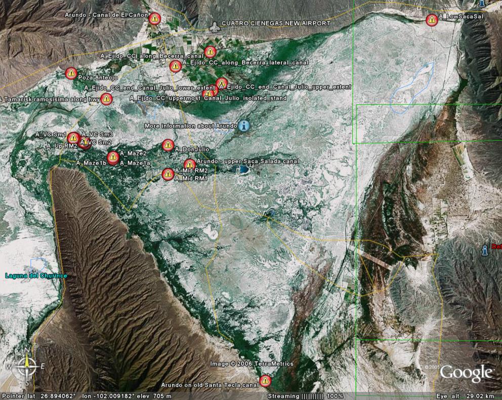
What is the history of Arundo in Cuatro Ciénegas, where is it established now, and what is the future outlook?
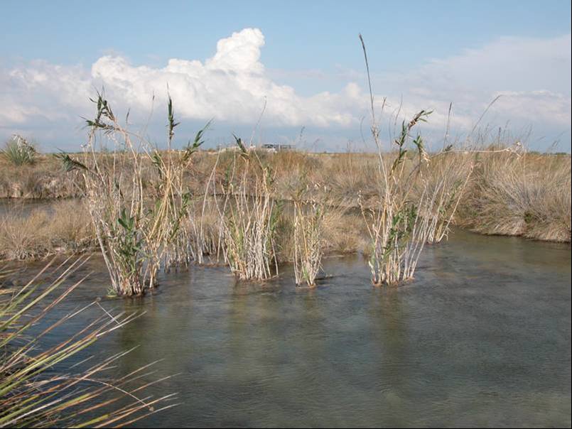
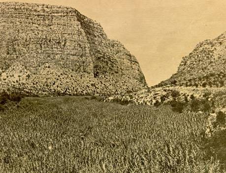
We have yet to thoroughly survey the entire ANP for presence of Arundo, but what was know as of summer of 2004 was reported by McEachron, Hendrickson and McGaugh at the 2004 meeting of Cuatro Ciénegas researchers, and Hendrickson's presentation at that same meeting reviewed what he could find out about the history of Arundo in the region and its potential environmental impacts. It is not known exactly when Arundo first invaded the Cuatro Ciénegas valley, but photographic documentation from not far downstream between El Cariño de la Montaña and Celemania provides some clues. As seen in a this series of photos
the type locality for the later-named endangered endemic darter, Etheostoma segrex, was photographed in 1961 by its first collector, Dr. Robert R. Miller. His photo shows a small river flowing through an open mesquite grassland with ample shallow riffle habitat with little shading by riparian vegetation. In Miller's photo, one very small stand of Phragmites or Arundo is visible in the lower right corner, but by 1968, the locality had been converted to a massive stand of the native reed, Phragmites,
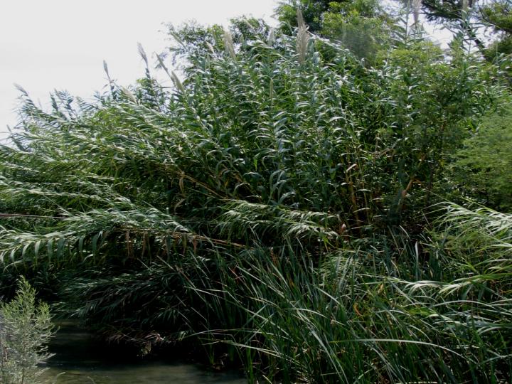
as photographically documented a short distance upstream by the botanist, Donald Pinkava, well known for his botanical explorations of the area. Phragmites is very similar to Arundo, and though it seems unlikely that Dr. Pinkava erred and identified what was really Arundo as Phragmites, the possibility remains and specimens that Pinkava may have deposited at Arizona State University should be verified. Nonetheless, by 2001, the entire river bottom along the highway through this area had been converted to the monspecific and very dense stand of Arundo donax that everyone who drives the highway through the canyon sees today.
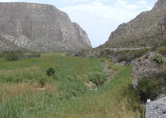
The river is now dammed by a small structure almost exactly at the darter's type locality photographed by Miller in 1961, and above the small impounded area
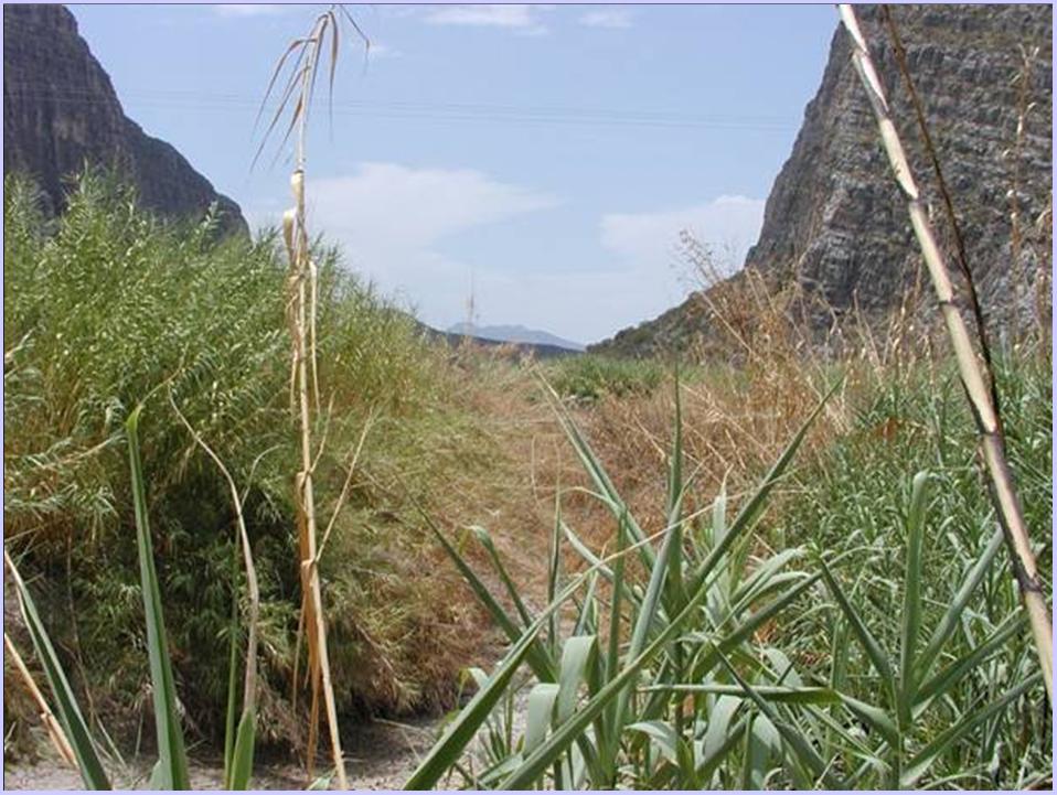
the river now flows at very high velocity through a narrow, deep and almost completely shaded channel, made that way by the dense encroachment of Arundo.
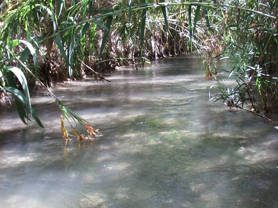
Access to the river anywhere in the canyon is extremely difficult due to the wide and very dense Arundo, the riffles on which the darter used to live are now gone, the stream is almost completely shaded, and the species is exceedingly rare (Hendrickson 2002 pers. observ.). Transition from native riparian communities to mono-specific, impenetrable stands of Arundo that drastically alter the natural morphology and habitat availability of hydrologic systems can thus obviously occur very rapidly in the region.
Will Arundo heavily impact Cuatro Ciénegas and downstream areas?
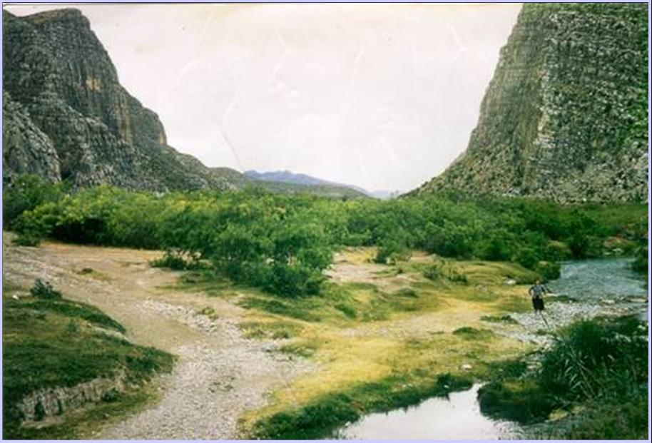
Though mostly still small, stands of Arundo now know to be established at widely scattered locations in the ANP could eventually expand to transform the sun-drenched and stromatolite-harboring Rio Mesquites and other rios and pozas of the ANP into habitats more closely resembling the Río Salado that now flows past El Cariño de la Montaña and Celemania (see photos above). If so, most all of the native, endemic organisms that now live there will disappear and the water flowing out of the valley will be greatly reduced by the high evapotranspiration rate of Arundo.
Arundo has clearly established massive stands with heavy impacts just downstream of the ANP and widely scattered small stands have been discovered in the ANP over the last few years. The arid environment of Cuatro Ciénegas is similar to that of the Santa Ana River basin in California. There is no reason to expect, nor data to indicate, that Arundo stands in the ANP will not expand as the species has done in the El Cariño and Celemania areas. The native riparian vegetation of the ANP's valley floor consists of very low clump grasses and low-lying salt-tolerant plants which (though quantitative studies have yet to be done) undoubtedly transpire far less water than does Arundo. Arundo could easily change the fully exposed rivers and pozas of the ANP to highly shaded, much narrower and higher velocity stream systems unfavorable to persistence of the native aquatic flora and fauna. Nutrient cycling in the valley's aquatic ecosystems will be dramatically altered. Arundo's record-setting high metabolism and extremely high standing biomass will quickly lock up large stores of nutrients formerly available to the native biota. Arundo is inedible to all but a handful of organisms, so nutrients once stored in edible materials will be largely unavailable. Not only will human access to these water bodies be highly impeded by impenatrable walls of Arundo, but the shading will kill stromatolites and there will be cascading effects throughout the rest of the ecosystem. Unlike the native bunch grasses, the high stem density and homogeneous nature of Arundo stands will impede movement of native biota, such as the highly mobile endemic box turtle. Arundo will be the tallest plant growing on the valley floor, and thus likely to attract the frequent lightning commonly associated with summer monsoons. This, combined with the record-setting high standing biomass of Arundo and it's incredible flamability, will increase fire frequency and intensity (heat) throughout the valley, focus fires on sensitive riparian areas, and make them much harder to control. Arundo is barely affected by fire, as evidenced by this photo of Benigno Vasquez showing participants in the Arundo workshop of June 2005 how quickly it regrows after burning.

Benigno manages the canal above Cuatro Ciénegas for the city and claims that evapotranspiration by Arundo removes 50% of the discharge of that now small canal. His observations concur with documentation of Arundo's high evapotranspiration rates in the scientific literature (below). Especially in the dry and windy desert air of this area Arundo would greatly decrease surface flows, resulting in less aquatic habitat for native biota. Diminished discharges will have increased water temperature variance and adverse impacts on the many endemics that are highly adapted to the stable temperatures of the valley's springs and their outflows.
Projected Cuatro Ciénegas water losses due to evapotranspiration (ET) by Arundo and comparisons with ET of native vegetation
Though the extremely high evapotranspiration (ET) of Arundo donax is widely cited in gray literature, citations of source data are rarely provided and/or the data are in terms that are not useful (e.g. lacking areal or temporal dimensions – e.g. “…as much as 2,000 L/meter of standing A. donax” (Iverson 1994)) for comparing the ET of Arundo to that of other types of vegetation. We could find only two studies that appear to provide potentially valid or usefully quantified estimates. A European study focusing on the potential of the plant for biomass production contains the statement, “Maximum water consumption (3.22 l/day/m2) was recorded between 13 August and 12 September, due to the higher evapotranspiration [that] occurred at that period” (Anonymous 2005), but with no indication of how the estimate was obtained. Tricia Zimmerman (pers. comm. 2005), provided information from her studies of Arundo and Salix growing in experimental plots at Sonoma Creek, Sonoma Co., California. This is part of her work in progress in the Masters of Science degree program at San Francisco State University, California, preliminary results of which were published (Zimmerman 1999). The data she provided are for mid-day water loss for 2 days during June. The stands she studied are very similar in stature and stem density to those of the Cuatro Ciénegas area, but temperatures in her study area were lower and humidities higher than in Cuatro Ciénegas, so ET of Arundo in Cuatro Ciénegas would likely exceed what she found. We used her data to conservatively calculate yearly ET by assuming that Arundo in CC might evapotranspire at the levels she recorded during the period from 1 hr after sunrise to 1 hr before sunset during 8 months of the year. Our estimates consider that Arundo would be dormant (not transpiring at all) outside of those daily hours and during all of 4 months of the year. This is obviously a huge, but reasonable simplification that, if anything, would likely underestimate actual ET in Cuatro Ciénegas. Applying the reasoning just explained to Zimmerman’s data, however, produced an estimate of Arundo ET in Cuatro Ciénegas of 6,326 liters/m2/year or, on average, 17.3 liters/m2/day.
As recently comprehensively reviewed by Shafroth et al. ( 2005) (see Table 1), other riparian vegetation common in the area of Cuatro Ciénegas has been demonstrated to have generally far lower ET. They found 9 studies that estimated ET for the notoriously invasive Salt cedar. Evapotranspiration estimates for that plant range from 0.6 to 3.4 and average 1.21 m/year (= 3.3 liters/m2/day). As reviewed in the same study, millions of dollars are invested every year in the U.S. and elsewhere in Salt cedar control efforts, primarily because of its high ET. The same study reported results of two studies of mesquite ET and 6 of ET for mixed mesquite, salt grass, sacatón and annuals (including several estimates from northern México) – communities very much like those found natively in riparian areas throughout the APFFCC and formerly downstream. The ET estimates for these communities ranged from 0.11 to 1.6, and average 0.6 m/year (= 1.64 liters/m2/day), or about half the average for Tamarisk (Salt cedar). The data we have found for Arundo thus indicate its ET to be anywhere from equal, to more than 10x, that of Tamarisk, and more than 20x as great as the ET of the native riparian vegetation of CC.
Table 1 - Adapted from Shafroth et al. 2005.
| ET estimates | ||||||
| (m/yr) | mm/d | |||||
| Vegetation type | min | mean or single value | max | min | mean or single value | max |
| Saltcedar | 1.20 | 2.10 | 3.00 | 0.00 | 0.00 | 0.00 |
| Saltcedar | 1.00 | 2.20 | 3.40 | 2.74 | 6.03 | 9.32 |
| Saltcedar | 0.70 | 1.92 | ||||
| Saltcedar | 1.30 | 3.56 | ||||
| Saltcedar | 1.70 | 4.66 | ||||
| Saltcedar | 0.70 | 1.05 | 1.40 | 0.00 | 6.25 | 12.50 |
| Saltcedar | 1.10 | 1.15 | 1.20 | 1.00 | 5.50 | 10.00 |
| Saltcedar | 0.60 | 0.85 | 1.10 | 1.64 | 2.33 | 3.01 |
| Saltcedar*** | 9.05 | 24.80 | ||||
| means (excluding ***) | 0.80 | 1.21 | 1.23 | 0.88 | 4.46 | 8.50 |
| Cottonwood | 1.40 | 2.35 | 3.30 | 3.84 | 6.44 | 9.04 |
| Cottonwood | 1.13 | 1.61 | 2.08 | 3.10 | 4.40 | 5.70 |
| Cottonwood | 1.00 | 1.10 | 1.20 | 1.00 | 5.00 | 9.00 |
| Cottonwood*** | 7.12 | 19.50 | ||||
| means (excluding ***) | 1.18 | 1.69 | 2.19 | 2.65 | 5.28 | 7.91 |
| Mesquite | 0.58 | 0.40 | 0.88 | 1.60 | 1.10 | 2.40 |
| Mesquite | 0.60 | 0.65 | 0.70 | 1.64 | 1.78 | 1.92 |
| means | 0.59 | 0.53 | 0.79 | 1.62 | 1.44 | 2.16 |
| Salt grass / saltcedar | 0.70 | 0.75 | 0.80 | 1.00 | 3.50 | 6.00 |
| Salt grass | 0.30 | 0.75 | 1.20 | 0.82 | 2.05 | 3.29 |
| Salt grass | 0.40 | 1.02 | 1.64 | 1.10 | 2.80 | 4.50 |
| Sacaton grass | 0.11 | 0.35 | 0.58 | 0.30 | 0.95 | 1.60 |
| Bare soil & sparse annual weeds | 0.22 | 0.60 | ||||
| Annual weeds, grasses & bare soil | 0.60 | 0.65 | 0.70 | 1.64 | 1.78 | 1.92 |
| means | 0.42 | 0.62 | 0.99 | 0.97 | 1.95 | 3.46 |
| Mean Mesquite,salt grass, weeds | 0.47 | 0.60 | 0.93 | 1.16 | 1.82 | 3.09 |
| = from Shafroth et al. 2005, otherwise calculated here from their data | ||||||
| = outliers (generally indicating inconsistency in units within study or out of line with others for same veg type | ||||||